Friday, December 28, 2012

Saturday Snow Blog...Coldest early January in years to follow....


 WRF-NMM Radar

  (CLICK ON ALL IMAGES FOR A LARGER VIEW) It will be nice to wake up Saturday to a classic New England Snow Sky and that distinctive smell only sensed by die hard New England Winter lovers (if you like snow!). It sure has been a while for many and this one should deliver. Snow looks to develop (lightly at first) Mid-morning to the west and south and make progress off to the north and east thereafter. Be advised but not surprised or discouraged if you start with a few raindrops.
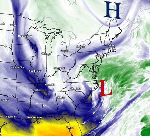
Though I just do not see that happening for too long if at all with such cold air aloft projected. Snowfall will increase in intensity as the low pressure nears from our south and eventually looks to pass just southeast of The 40/70 benchmark and pass off to the northeast of Southern New England Sunday morning with some backlash snows and ocean enhanced snows falling along east coastal area’s.
This track is just a bit farther south than the last storm and makes all the difference in the world this time with ample cold air aloft to support a snowstorm for many folks. The area highlighted to received the most snow is Norfolk , Bristol and Plymouth Counties in eastern Massachusetts away from the immediate coastlines as well as central and northern Rhode Island and northwest Connecticut . Locations along the IMMEDIATE coast will be fighting marginal temperatures and dewpoints at the surface . The hope is the intensity will help drag down the colder air aloft (850mb temps) for a snow pack all the way to the Cape Cod Canal and perhaps a bit beyond. 
   <<<850 mb TEMPERATURES
The rest of Southern New England is in for a widespread 3-6” of snow with this one, and for that Winter Weather Advisories are in place for all, with Winter Storm Watches in place over the favored higher prone areas. The reason for the higher amounts east is the closer proximity to the storms center and temps and dewpoints optimal for a snow growth region. Also often times in these events a coastal front forms from Gloucester Ma-Plymouth-The Cape Cod Canal and snowfall just to the west of this front becomes enhanced as well as enhancement from the ocean from a LIGHT northeast wind fetch…Key is LIGHT, so it does not pull the milder air in from the Atlantic Ocean, so that is what is forecasted as the Max Zone. This is a fairly quick hitter and is out of here by dawn on Sunday, with perhaps a few ocean effect snow showers affected extreme eastern areas and Cape Cod on a north wind. The snow that falls appears to going nowhere fast as the very cold air rolls in behind from southeast Canada and will be going nowhere fast as well. In fact it could be the coldest first week of January for some dating back to 1996 ! It will go from 30’s to highs, to 20’s to teens for some through the first days of 2013. Far cry from non-winter last year eh!? The active pattern will take a breather with the renewed cold as it will be “Too cold to snow”. Thanks for reading and have a wonderful weekend          Anthony

Friday, December 21, 2012

Now Lets See What Winter Has to Offer, Officially !

   Abnormally mild temperatures and much needed rainfall today for many throughout Southern New England was good to see as we are almost at normal precipitation levels now for the month of December with more shots coming ahead. The wind was really whipping out there with gusts reported 35-60mph region wide with Category 2 force Hurricane conditions atop the Summit of Mount Washington New Hampshire for a time with a strong low pressure system passing over western Vermont. Much colder air is filtering in now behind our storm system. There is still a large cyclonic flow over the region and lots of cold air aloft streaming in as well, this will set up for temperatures to drop this evening and not recover to much if not at all Saturday under mostly cloudy skies with some partial sun certainly expected. That sun could bubble up some cold air induced instability clouds which could drop a few snow flakes, or rain showers. This process could occur a few times throughout Saturday , especially the interior of central and western  Southern New England. Beyond Saturday High pressure takes control bringing quiet and cold weather for Sunday and most of your Christmas Eve Day. 
Sure by now you have heard me mention the possibility of a White Christmas still exist and that holds no more true than today as our guidance is trying to pull a rabbit out of its hat. Sure, some may be thinking models have all shown this before under great agreement only to fail in the end. Well it goes further than that beyond both operational and ensemble guidance, and especially after Christmas. As far as the snow possibility Christmas Eve into Christmas Day, it is noted right off the bat that there will not be a lot of moisture available and this does not look like a big deal at all. It will be a big deal if many wake up to flakes falling though for sure and maybe a sign off things to come and put a smile on a few faces. 
(Click on graphic for larger image) 
A little dip in the Jet stream will occur Sunday afternoon over the Mid-West tapping into a bit of Gulf of Mexico moisture and likely forming a weak surface low over Tennessee or Kentucky and then chug right through the Mid-Atlantic off the New Jersey coast and  south of Southern New England Christmas morning perhaps bringing enough moisture on the northern flank to deliver a light accumulating snowfall to most our region. There is likely to be a few shifts in the precipitation shield and where the heaviest available moisture will fall due to a newly formed pattern just starting to take shape in the wake of today’s bizarre weather on the first day of Winter, with some respectable brief blocking in place.  I will hold of on specific amounts for now, though a coating -3” is a safe call at this point if all pans out. We should clear out later in the day and remain quiet through most of Wednesday before we watch what could be or first official Major Winter Storm of the 2012-13 season sometime the late Wednesday through Friday time period. This one is being indicated as a phaser with Northern and Southern streams  on model guidance and a Low coming out of the Gulf Of Mexico loaded with moisture and carry nothing with it but potential for intensification up the eastern seaboard. We have seen models do this before only to lose the solution just as quick though it coincides with a deeper set of support. That would be our teleconnections and specifically The PNA which is now showing signs over going positive for the 1st time in a while. The positive PNA is more likely to build a ridge over the western states which in turn develops a trough over the eastern states, and when you coincide that with a -NAO which often develops strong blocking near Greenland , it makes that eastern trough prone to become more amplified and more prone to the frequent  opportunity of strong coastal storms/Nor’easters. 

The all import block keeps for the most part strong Canadian High Pressure (cold air supply) locked to our north along the Maine and Canadian borders. This is why I feel a bit more confident in at least stating that our pattern change is starting to evolve now and fairly quickly. There still is likely to be mixing issues as there are with many if not all coastal storms, but its definitely a step in the right direction for snow lovers. More Info as it becomes available on this… Thank you for reading, and if we do not speak, a very Happy Holidays to all of you and yours. Oh,….NOW you winter lovers can start complaining if we see no snow. Its official !    ~Anthony 

Wednesday, December 19, 2012

Bring in the Winter Solstice with a BANG ! Again ? Is it a sign?


(CLICK ON ALL GRAPHICS FOR LARGER VIEW) A Blizzard is underway ! Just not here in Southern New England as many would wish, while others are just fine with this somewhat mild (depending on exact location) and breezy weather as of late. While in the long-range, there appears to be no major shift to the current pattern that has evolved over the past week or two which send most storms over or to the northwest of our area, there will be a few wrinkles in it that maybe cold enough and just at the right time to produce some wintery weather for us depending on storm development and the track  and redevelopment potential as always. 
Thursday looks very nice by mid-late December standards with a chilly morning start and perhaps some ocean effect clouds on Cape Cod with a few rain or snow showers early. For the rest of our area we will see sun and clouds with light winds and temperatures right around where they should be this time of year in the upper 30’s to low 40’s on average. Enjoy the peaceful day because Friday some big changes come in. 

Friday as a strong low pressure system spins over the eastern Great Lakes , a new low will form near or over New England. This is a POTENT front passage and one that will bring with it a burst of strong to damaging winds, showers and downpours with the potential of a thunderstorm to our area. A Thunderstorm you ask? On the first official day of Winter?. That’s right and you don’t have to look far back to see the last time that occurred because it happened last year on December 21st. What an extremely odd coincidence, and may add new meaning to the term Starting off Winter with a “bang“. Behind the downpours, wind and potential thunder, temperatures will begin to crash as the winds shift behind the departing low and perhaps bring a quick change to snow western and central areas before most the moisture escapes to our north and northeast Friday evening. 

So here are the finer details as I see them shaping up on Friday:  Mainly light showers come in well ahead of the front before dawn Friday to southwest areas of Southern New England, progressing steadily to the northeast there after. Most the area will be in showers/downpours early afternoon ir late morning with perhaps a thin convective line affecting our area around or shortly after noon time that will bring strong to perhaps damaging winds gusting 45-55mph, perhaps a bit more. If we hit 60mph in any gusts associated with the downpours of thunder, a isolated Severe Thunderstorm warning cant be ruled out. (Bizarre)  After that line crosses with the front we wil go into the dry sector before the cold air starts to charge in here from the WNW as the main vortex off to the west swings on though bringing with it MUCH colder air. Most in our area will see ½ -1’ of rain with a good possibility of a bit more throughout the SNE region.

 Cold air comes pouring in starting Friday night both at the surface and especially aloft as the Vort max swings through and sets the stage with still a broad cyclonic flow over our area for the potential of snow flurries and snow showers falling for many on Saturday along with temperatures that will continue to fall on a breezy active WNW wind still. Remember entering in Winter with a bang?, well that is what might occur quite literally as this cold will stick around for a few days it appears.
 The storm that exits Saturday will set off/up a trough near or just offshore into the late weekend and towards Christmas Eve. At the same time , a weak low may ride the trough and bring the shot and a bit of light snow to fall into Christmas Day !  Though please do not get hopes TOO high for that as most the time in that situation moisture stays suppressed to the south. Will certainly be keeping an eye on that along with signs now that the pattern will remain active but now possible with just enough cold air to our north to make it interesting.  Our teleconnection indices remain fairly supportive of stormy weather with the North Atlantic Oscillation projected to remain negative along with the PNA steadily rising. Speaking of up north. Maine continues to be ground zero for snow as of now. Some mountains up there have already picked up FEET of snow and the Friday storm we should keep adding to those. That snow pack is important and will continued to be monitored. Thanks for reading. ~Anthony

 If you missed its release Tuesday, Here is The “Southern New England Weather Probability of a White Christmas” this year

Saturday, December 15, 2012

*NEW BLOG* All aboard the "Storm Train"... Details on all.


As we wrap up a quite extended period of dry , above average temperature period of early December, a very active period of weather awaits for much of next week starting Sunday and also shows signs of this continuing right through much of December. Most this next week will be too mild in Southern New England for any snowfall of significance though very cold signals are being indicated starting next weekend and beyond. Below I will break down each event scheduled for the week and what may lie ahead as we welcome in the official Start to the Winter Solstice next weekend. (CLICK ON GRAPHIC FOR LARGER IMAGE)


Storm/Event One ..Sunday-Monday : Clouds and overrunning moisture will increase across our area this evening into the overnight as Low pressure now over the western Great Lakes moves towards our area Sunday. As it does so a new Low will form south of Southern New England during the morning hours of Sunday. There will be cold air that will be tough to budge initially so expect some light snow to break out for most our region after mid-morning . Those closer to coastal location may see a brief period of snow that will transition through some sleet before completely over to rain not long after. Further inland , the light snow burst and sleet combination will persist longer and the cold holds firmer for a longer period of time. Dry dew points in the interior will help in this as well with Evaporational Cooling expected as precipitation begins to fall, a brief drop back in temperatures is likely to occur.  For this reason, we may see a few Winter Weather Advisories pop up Sunday Morning . There also is the likelihood as temps warm aloft as the precipitation enters that the snow/sleet combination inland may turn to a period of Freezing Rain before the eventual transition to rain as all layers warm by evening time. The most snow will fall in the Northern Berkshires of western Massachusetts and along the border of Vermont into southwest New Hampshire where 1-3” appear likely with a few locations possible to see a bit more depending on how long temps aloft stay cold enough. This should be until approximately 7pm Sunday evening. Precipitation is likely to come to a brief end  during Monday morning before the next wave of low pressure approaches from the west/southwest


Storm 2 Monday pm through Weds: This storm will have a bit more juice with it but also have warmer air incorporated into it as it approaches and already mild air in place upon its arrival. Most of this storm will be rain, heavy at times and gusty winds from the  east/southeast into the shores as Low Pressure is expected to pass right over or just off the Southern New England Coast. Important to note there still is minor disagreement on the eventual track and potential redevelopment of a new low off the Mid-Atlantic coast. Though most indications are a breezy Rainy event with possible mixing along or near the Route 2 corridor into southern Vermont and New Hampshire . This storm may carry the potential of some minor coastal flooding and beach erosion as well. Colder air will be pouring in briefly on the backside as the storm passes off to out NNE so there is a slight shot at a switch over to a period of snow. Will continue to keep eye on that.


Storm 3 Potential Friday through The Weekend:  There is a 3rd storm potential which in the end could end up being the most potent out of the bunch. This storm , again is highly dependant on the track. Behind storm 2 , colder air will pour in so that complicates issue farther. More snow potential with this one, again especially across the interior. This system is 5-6 days away and lots of time for a different pattern to become establish due to the prior two storms. Little side note: Portions of Maine are in for 1-2 Feet of snow, perhaps near 30” for some through this period…Lots of Juice !

Beyond this , current indications are the coldest air of the season pours in and perhaps sets the stage for snowstorms for our area as we officially welcome The Winter Solstice in Here Dec 21st. One model shows a Christmas Eve-Christmas Day storm with another very potent coastal storm coming in December 27th. 
So, though we saw a few minor snow events in November into early December, we have been dry and mild as of late leaving many asking “where is Winter again“?  “Will this be a repeat of last year ??”… Lets let it officially start first ! How does that sound?. Also, if your worried that all this rain means it will continue through Winter, that’s simply a gut feeling and not true at this point. Back in December of 2010 a HUGE rainstorm occurred mid-month. After that, Winter arrived in a BIG way and we never looked back….No Panic yet snow lovers.


Tuesday, December 11, 2012

Fear Not....Stormier Times Lie Ahead...


Quiet mild weather has prevailed for the most part through much of December so far with a few periods of rainfall that have not even begin to put a dent into what will end up a WELL below normal year for  precipitation as some are running as much as 9” below normal. It remains no doubt that we are in desperate need of precipitation badly. Its not in the cards for the next few days as High Pressure looks to keep us right around seasonable for this time of year and dry. I am watching a potential storm system for late this weekend into early next week that could make for a snowy scene Sunday as the San Francisco 49er’s come to Gillette Stadium in Foxboro.  I’m sure you have heard, ( hopefully from Southern New England Weather ) that a pattern change appears in the works and signs continue to indicate so as The Projection of The North Atlantic Oscillation (NAO) continues to drop along with the potential rise in the  Pacific North American Pattern (PNA).

 Both elements indicate colder and stormier times lie ahead between now and at least  December 27th. That along with finally a loosening grip of domination with the Northern Jet stream which has sent mild air ahead of cold fronts as storms arrive passing to our northwest, seems to be weakening and a more active Southern Jet stream is prone to take over bringing deeper moisture into storms potential tracking up towards the N. East Coast  from the Gulf of Mexico and the Southeast united States. The 500MB pattern also suggests this and has for quite sometime regardless of all the Mid-Long Range outlooks that have been floating around now and then for  above average temperatures for much of the United States. All reality is that the signs have been consistent just the opposite for some (SNE) and now our Ensemble and Operational weather model guidance is starting to come around late in the game. This is not a surprise though as confidence in weather models always is lower the further out in time and increases as time draws near. This is especially true when other factors disagree amongst each other, ie. Blocking, lack of pacific Northwest data, ect., ect.  As far as specific dates and amounts for specific locations, that remains unknown this early in the game, though there is increasing confidence in a weak storm system  approaching from The Ohio River Valley late this weekend and a marginally cold air supply parked off to the North of New England in southeast Canada. This should spell out light wintery precipitation coming in late Sunday, possibly becoming a bit enhanced approaching Southern New England early Monday along with a weak trough that could keep lighter precipitation falling in eastern areas. The potential is there for a few inches of snow with this one. Not a blockbuster though as there will be no phase with the Southern Jet Stream. That could change as we approach the mid-later half of next week as a ridge will build near The Four Corners and send a deeper trough , tapping into Gulf of Mexico moisture and sending a strong surface low up the eastern seaboard with a -NAO (Greenland Block) in place. That storm appears around the 19th-22nd timeframe and looks Juicy !

 The Official Start to the Winter Solstice is Saturday of next week and we may coincidentally be just getting it going.      ~Anthony 

Saturday, December 1, 2012

*Revised* Onto December..Up & Down, whats ahead ?...

As we close the door on a very dry , below normal temperature wise November,  ( November SNE data ) we now have opened the door to a somewhat wintery start to Meteorological Winter and December. Many locations across Southern New England this morning were greeted to light snowfall and widespread coatings across the region along with unseasonably cold temperatures. Almost like a script right ? Well it certainly will not last long as winds will shift overnight and into Sunday from the south and slightly southwest with high pressure settling further to the south and push a warm front north into and through the region and bring us well above normal for this time of the year in the 50°’s !  That should last until early Wednesday before a strong cold front will bring couple downpours or even a rumble of thunder with a uick switch to snow on backside central and western SNE Wednesday afternoon and much cooler weather back where we should be this time of year to follow.

  Signs are "back" (a bit delayed) that upstream blocking near Greenland  could again try to re-establish itself along with a disintegrating massive low over the Gulf of Alaska finally leaving that area and a Polar Vortex over central Canada that has been stubborn to budge, finally start to make the track South/Southeastward towards the lower 48. All this potentially indicates a cooler and stormier pattern setting up in the mid-term and especially after December 9th time frame . One of our reliable models indicates a Nor’easter around that time with interior snow, a coastal mix and strong winds. This is something we will watch over the coming days and bring further updates as needed. A combination of that model and another long range model indicate the storminess may not stop there as blocking tries establishes often in the upper 500mb pattern and a recent dominating Northern Branch Jet Stream begins to shift southwards and allows for phasing with the Southern Jet Stream which has lacked so far with cooler air in place though has occurred back in late Oct and Nov with Sandy and the Nor'easter respectively. This increases large storm potential greatly for  The Mid-Atlantic and Northeast. Its still has to come together though as it has potential to do so with key factors en route perhaps, but certainly not a given. It will be something to monitor and can be nothing but better news ahead for Winter lovers.

 So Enjoy the mild air and break next few days and for the  winter /snow lovers, time to get down and dirty.  Thanks for reading.     ~Anthony

Sunday, November 25, 2012

Potential Miss Likely ?.. Still Early.


So far in November we have been below average temperature wise daily more than above for many locations throughout Southern New England, except for a brief period of warmth  from the 8th -13th . The issue is that we have also been very dry and well below normal precipitation as well.
 The cold is explainable due to an active northern stream coinciding with a North Atlantic Oscillation which predominately remains in a negative phase. The precipitation side is a bit more complex. Rumors have been flying of a potential storm Tuesday and Wednesday, and granted models for a time did indicate a minor to moderate snowfall around and south of The Massachusetts Turnpike  for a time, in the end the very cold and dry air that has been over us seems to be winning this battle and will squash most if not all moisture to work with in advance of low pressure well to our south with this potential storm Tuesday into Wednesday. Even when you have what you think all the players are lined up for a potent coastal storm, not all things align the way they need to be. The weather works in strange ways, and seems as though the harder you try to figure it out, the more you are left scratching your head. There are always surprises though and more often than not a storm does “surprise” us more than it does when it is expected, or at least it seems that way to many I’m sure. 

So the latest with this potential storm has a more zonal flow with the northern jet dominant and not able to tap into little Gulf of Mexico moisture that will be available and the dominating cold high pressure that will move off to the Northeast of Southern New England between now and when moisture starts to gather to our south and west will eventually hold most that moisture close and tight to northern flank of the precipitation shield as a WEAK low center passes south and east of our area Tuesday.  There are some indications that at the last minute the trough will tilt just enough in response to blocking to swing the storm more to the north and perhaps intensify within close proximity to the Gulf of Maine in the open waters and throw back light precipitation near the coastlines or even a weak trough development connecting between that low and a weaker one off the north of the Great Lakes forming a band of ongoing light precipitation.  This is yet to be seen or known, but a possibility nevertheless giving blocking trying to firmly establish right in time. To wrap it all up, chances are most if not all miss out on any snowfall other than a coating to an inch especially to the south and possibly to the east. 
There is another potential for a similar setup next weekend that bears and will be watched as well along with the fact that signs continue to indicate a near normal or below normal December in the temperature department and an active storm pattern developing into at least early December with some swings likely which could only help in storm development.  Lets all remember guys, it is VERY early in the game. Even for Boston, during our snowiest past winter seasons the first snow sometimes does not occur until mid -December and sometimes even holds of until early January. I feel many have become spoiled and expectations high especially the past few seasons with early , abnormal snowfalls. This is NOT the norm so to speak. So just hang in there. Meteorological Winter starts in 6 days with the official start to the Winter Solstice still over 3 weeks away. Thanks for reading guys !    ~Anthony 

Friday, November 16, 2012

Quiet heading into the Holiday..Or Is it?


After a few weeks of active weather battering our coastlines and displacing many from their homes and daily routines, the weather has quieted down dramatically and will continue to be quiet through early next week. It’s a very important travel week with the Thanksgiving Holiday on Thursday, so I try to leave all possibilities open. For now though, High pressure remains situated and will continue to do so off to our WSW blocking any moisture from coming in and giving a seasonable to a bit below seasonable flow from the  WNW.  There will be clouds from time to time and a slight increase in them as each day goes on from Saturday through Wednesday. Also, temperatures will moderate a BIT each day. It appears as though the entire period will remain dry. Afternoon breezes are possible, especially to the S &E.

If you remember earlier this week, I had mentioned a potential storm around thanksgiving, well, models and more importantly our Jet stream is forecast to be much flatter and a huge High Pressure system to the northeast of Southern New England looks to be in control per latest guidance. That Cold High (Heavy air) should win the battle with building moisture off the SE Coast of The United States trying to gather, form and push north.  If that High Pressure system does establish itself as forecast off the the northeast , you can forget about any storm coming this far north to have any direct effects on our area , it simply wont win that battle. Though If that high settles in a bit more west of its current Forecast, a shift closer to the coast most definitely could occur. For many though this is welcome news as many will travel in order to make it to their Thanksgiving destinations and quiet weather will be a welcome sight and as off now that is what we are likely to see. Though it remains a pattern that looks like it could QUICKLY change and at any time support a closer pass to the coast with a building Greenland Block by around Tuesday.
 The North Atlantic Oscillation  (NAO) forecast is now sending out mixed signals between a Positive and Negative phase slated right around the holiday which often sends guidance into an erratic frenzy, and this is why I continue to be reluctant not to toss this storm in the Atlantic Ocean just yet. I also believe it is the right decision due to the importantcy of travel next week to keep all doors of possibility open.
 Please stay tuned for further information on this potential which would look to carry a cold rain and wind if it were to pass close enough. Possibly even some snowfall to the interior. As of now , the trend is just some clouds, steady onshore flow , minor splash over on the coast and erosion, large surf,  and clouds and fog even if the storm does not impact us head on. Hopefully it stays quiet and dry for Turkey Day, and then weather lovers can really start to prepare for what may be a wild ride in December. Thanks for reading and do have a great weekend !     ~Anthony

Saturday, November 10, 2012

Brief warm up...Return to the old.

The Nor’easter is behind us thankfully and we saw a very nice day Saturday only to get better on Sunday with some approaching 60° under plenty of sunshine. Just a gorgeous day for Football at Gillette as The Bills come into town against The Pats at 1pm. The ridge maxes over Southern New England Monday ahead of a cold front to our west. Temperatures in the upper 50’s for northwestern zones and into the 60’s further east. What a treat! You will also notice a bit of humidity especially south and east as dew points will rise into the upper 50’s to low 60’s. All this is very temporary though as the cold front waits back in the wings for Tuesday. It will become breezy Tuesday ahead of the front passage and temperatures ahead of it will max in the morning hours near 60°
.
 Showers will associate with/ the cold front as well as the risk of a gusty thundershower as K Indicies rise into the 30’s. Behind the front we all turn much cooler for the reminder of the week with daily highs back into the 40’s and low 50’s and cold night time lows near/bellow freezing for the interior . At the same time the blocking we have had the past 3 weeks tries to become better established  up near Greenland and coincides again with building moisture near and off the coast of the southeast Untied States . We will have to watch again for potential coastal  Atlantic development next weekend with again interest along the northeast coast. Remember Hurricane season does not end until November 30th . Another coastal  storm would surely be added salt in the wounds for many who do not need it for sure, but Ms. Mother Nature could care less, its up to us to remain vigilant and prepare for anything she decides to throw at us. Thanks for reading !    ~Anthony

Tuesday, November 6, 2012


Our pending Nor’easter is taking shape off the Outer Banks of North Carolina this evening.  You can see the cold digging down behind the storm which again is creating a huge dip and a trough for another storm to ride up the east Coast and with stil a decent block in place, once again it has nowhere to go, Its trapped. The block could start to release Thursday am and “pull” the Nor’easter away with it. Not much has changed in the forecast over the past few days other than my statement that “it will not snow”. It is now likely that many across Southern New England will see their 1st flakes of the season and some likely to see accumulating snow.
The storm will continue to move off to the NNE and pass near or over benchmark 40/70 Wednesday evening. Meanwhile high pressure will be parked off to the north of New England along the Canadian. US border. That as you know means trouble most the time

. There are a few wildcards with this one. Very marginal cold support from 850mb temperatures. With them being marginal, in order for widespread snowfall, precipitation would have to come down at a heavy rate to “tap” into the colder air aloft. Right there, this setup favors higher elevations. The precipitation portion of this storm will likely be unknown right up to the last minute honestly though the potential is there for snowfall almost right to the coast. This does not seem likely to me at this point. Though from Worcester MA points west up and down SNE, it is. Also there is the chance of some freezing rain which could occur after an initial burst of snow across inland areas.

 This is due to models indicating a spike in temperatures aloft while surface temps remain at or below freezing for some. Dewpoint and wet bulb temps will need to be monitored very closely just prior and during the storm. In spite of that, I think most all transition to rain except those above 800-1000 ft. When night falls Weds eve, some could go back to snow. It all sounds like a lot, though in reality there is not much moisture to work with in this storm. Western SNE looks to see about a ½” of Precipitation and those numbers could increase to near 2” on Cape Cod & The Islands. The BIG story with this storm will be the winds. They will start to increase from south to north during the morning and reaching sustained speeds of  20-40 MPH from NW-SE by the afternoon.  Wind gusts will begin to approach 30-35mph across the interior, perhaps some near 45mph. Gusts closer to the coastline are likely to exceed 50mph with some near or over 60mph !. For this potential, High Wind Warnings and Wind Advisories have been posted by The NWS.

 There also is potential for minor to moderate coastal flooding and possible beach erosion.  Best guess on timing is as follows : Precipitation likely to start from S-N during mid morning Weds, ending Thurs mid morning, perhaps earlier. The winds will be steadily increasing come Wednesday morning and  maxing late night and calming down  early Thursday afternoon, though still remaining breezy. So, This is you typical Nor’easter. Unfortunately it come just over a week removed from the worst storm many in the Northeast have even experienced. My thoughts and prayers remain with those who lost love ones, are displaced and with out power. Its going to be cold !  Good news is with block releasing a bit and a huge ridge building to our west, we will turn mild early next week. But, guess what?….The block will be back…..That’s it for now , thanks for reading !  ~Anthony 

November Nor'easter Set To Strike

Freezing cold weather this eve is setting the stage as our Nor'easter approaches Weds. It now appears that the 1st snow will fall for many in Southern New England. Where snow does not fall, a cold rain will fall. There also is the risk for some freezing rain after initial burst of snow for some.  We still expect strong to damaging wind gusts, large swells , some beach erosion and possible power outages.

Thursday, November 1, 2012

#SNEwx *NEW BLOG** ... Not again !


Sandy is gone now but what she left was an area in shambles. My Thoughts and prayer continue to be with those affected on the East Coast..

So, Sandy is gone but her roots remain. The NAO (North Atlantic Oscillation ) was tanked during Sandy, perhaps the lowest in many many years along with a strong Greenland block.  We now see signs the NAO is transitioning or going “up” a bit. It is during these times of transition that weather can become eventful. The potential exist from another phasing of the northern and southern streams sometime mid next week. There will be a large upper level low pressure system over central Canada and a potent energetic disturbance coming out of Kansas to the southeast U.S. states. There will likely be a redevelopment of Low pressure off the  East Coast near the Carolina’s. At the same time a HUGE dip in the jet stream will be occurring along with the persistent blocking pattern well off to our northeast.  The Precipitation will wait for the Jet to go negative and then make its way up or just off the East coast, perhaps head northwest  before once again (Sandy) get pulled back by the negative jet and pushed in towards the E coast by The Greenland Block.  Timing looks to be late Wednesday perhaps through Thursday as another wave may ride up the negative trough.. Like sandy, there is no escape, though this will be NO Sandy , we got that stright?....Good ! . Not even close.
Still a bit too early for the specs, but the players are in place. Graphic 1: Below is a 2 panel model image of the 500MB chart and the 6 hour precip chart , timeframe Wednesday Pm
(Click Image to enlarge) On the left is the 500mb pattern, you can see the negative tilt to the jet representing initial precip may head out to sea.., though addition moisture to ride up from the southeast states could not escape. On the right: there you have a storm with quite heavy precipitation now. Low pressure situated JUST SSW of Southern New England. The low most likely would form off The Viginia coast then travel to the North...the block or "push' back to the coast is not as dramatic as it was with the Sandy set up, though is there and will be a major player.

Graphic 2 : Shows the 850MB winds which are the winds aloft and the potential for Gusts if brought down to the Surface. This model is indicating at least 75mph winds aloft at 850. But how do we get it to the surface?... From heavy precip and or convection which we know the model is showing here as well. Based on that , the potential exists for damaging winds with this storm, and in fact will be LIKELY if it forms . And Now the big question ....Will it be cold enough for snow? At this point the answer is no. 1: the track takes it west of Benchmark and continues N rather than ENE which would "pull" in the colder air behind it. With track further west, this would allow a more WSW -S flow bringing in higher dewpoint readings well above 32° to most of SNE, though slight shifts in track would mean a different story this go around. Stay tuned for the latest and Thank you for reading   ~Anthony


Sunday, October 28, 2012

**New Quick Blog ** (6:30p) Sandy now, & her Path into the Northeast


The first effects of Hurricane Sandy are arriving this eve..and conditions will continue to deteriorate and maxing in intensity late Monday through all of Tuesday..Expect hurricane conditions..some of my previous post on this blog aslo explain what to expect.. be safe and take this storm very seriously..Thanks    ~Anthony


Friday, October 26, 2012

What Sandy Could Bring.. #SNE QuickBlog (515pm)

Hurricane Sandy (now cat 1) looks to be losing warm core..maybe Post/extra-tropical..either way drop in pressure likely near its landfall.It appears she will be a long duration storm...with persistent TS force winds battering many areas for hours & hours & major inland flooding.Coastal areas will see beach erosion, very high waters coinciding with full moon. some storm surge is possible especial E &SE shores.Waves around or to the E of the circulation could be on the order of 25-40ft. There should be no downplaying th effects Sandy could have from Va-Maine from Sat-as late as Weds!If thats not enough on the back side of Sandy,a polar surge will lead to perhaps Blizzard condition's centered around West Virginia.yes SNOW.Folks in the path of Sandy, which very well could end up to be a Mega-Nor'easter should prepare for poweroutages and property damage.While Sandy most likely will not be"Tropical" this should NOT lead to any type of downplay,sure its a bit more benign if it ends up the case.Specifics on rainfall amounts,locations and sustained w/ and gust potentials will become clear as this storm evolves further N in Latitude.Just to throw a few #'s around, the potential for up to 15" of rain perhaps isolated higher amounts esp. near & to W & N of center.lesser E. Winds:WIDESPREAD Tropical Storm force winds appear likely for a LARGE area..strongest on EAST side of storm Sust. 35-45 Gusts to 80mph poss.Stay tuned for the latest, try to NOT to zero in on specifics at now.Still much time for shifts..#Sne track remains 

Wednesday, October 24, 2012

#SNEwx Update on Hurricane Sandy 12am


At 11pm Hurricane Sandy is a strong Category 1 hurricane with an exceptionally low central barometric pressure reading of 954mb as seems to still be deepening.Folks along E coast of #FL - Outer Banks and Mid Atlantic up into Southern New En
gland right through the Atl. into Maine need to be on guard..GA-VA should be spared for MOST part.There remains No imminent threat, though confidence of effects continue to increase with time. Storm is Massive in SIZE,effects could be felt inland especially if its hugs E coast.. More in SNE & Maine if a SE-NW lashing.Thurs. is crucial! short range Models play a vital role in potential validity.Time frame of potential concern appears Sunday-Weds from S-N or SE -NW.. ( odd to say that ) specifics to be ironed out next day or 2. Intensity/effects remains in ? due to position,Press.Falls/rises expected & if it loses Trop. characteristics.Will come clear again w/time. It will be difficult for Sandy to escape,just may though,&we will be spared. Wise to @ least have it in your mind nxt couple days,it'll help. More Tomorrow guys..Have a good one ! ~Anthony Apologize for the horrible appearance of this having some fronts,color issues ect.

Tuesday, October 23, 2012

Epic, or Epic Fail ? Prepare!


  I have made much talk the past few days over the potential for a big storm at the end of the month. Even speculation a few weeks back at this potential. As of today the potential is there and  increasing with miss potential just as high. Though extremely important to note there is NO imminent threat and still a very good chance this storm slips to the S& E of Southern New England.   So, what is this Storm we are talking about?. Right Now it is Tropical Storm Sandy strengthening that formed on Monday and is currently moving NNE at 20mph and has a Central Barometric Pressure reading of 993Millibars. She is forecasted to continue to strengthen and become a hurricane as early as Wednesday afternoon and continue to travel to the NNE.
 Hurricane Watches and even Warnings are already up for Jamaica , Cuba and Guantanamo.  Sandy is expected to ride up E of Florida and continue on a northerly path for at least a time, then some players come in. Does a front coming in from the Great Lakes hold its ground, speed up, Intensify and kick Sandy completely out to sea well south and east and completely spare us and make many of us look like hypsters trying to instill public panic, when in reality the potential had/has and continues to be very real, or does that front/trough slow or even stall near The Eastern Great Lakes and allow for Sandy to continue to the North, at which point that same trough would become negative tilted and allow Sandy to retrograde back towards the East Coast dangerously close to Southern New England near Halloween? Well that’s what one of our trusted model has been quite consistently leaning towards and an intensity projected capable to match or even exceed that of The  Great 1938 Hurricane. Add to that a  strong negative North Atlantic Oscillation , this will aid in storm development, intensity . There is about 2-3 days at MOST to nail this down, we should know by Thurs pm if this is a miss or that we seriously need to heed the warning our only weather tools are sending us and prepare for something that we knew would come soon or later . Southern New England is certainly NO stranger to considerable effects of Hurricanes. Edna & Carol two weeks apart in 1954, Gloria in 1985, Bob in 1991 and also the Perfect Storm later that year and many less significant so to speak in between.  The are a couple things we do have in our favor to limit intensification though. As always the case further north in latitude is cooler sea surface temperatures and the general fact that cyclones tend to accelerate as they traverse northward . Certainly there is no imminent threat right now, but time is running out while guidance is giving us fair warning of potential. Make the best out of it, prepare regardless, understand that the potential is there for major to extreme damage near Halloween and just as fair game that this thing spares us. Sandy may not even be tropical, she is likely to transition into an extra-tropical storm with lacking warmer features of tropical origin.  That would NOT take away from potential impacts as some models are indicating a VERY low central barometric pressure associated with it if it comes north and that will take hours and hours to uncoil . The storm is expected to be monstrous in size with an extraordinarily large wind field. To sum it up, be prepared that all this could be another highly talked about storm that spares us (not many would complain) or that finally after years of being “overdue” that the big one could hit. Thanks for reading guys !   ~Anthony
Below for weather fanatics is a graphic showing a few of recent model runs and what forecasters are facing among many other factors, teleconnections, Upper level lows placements…ect ect….but hey, its what we live for !  

Sunday, October 21, 2012

*New Post* All quiet Now...End of the Month, Not so much!

In an interesting development over the past few days, models have quietly geared towards what could be a tropical system that comes dangerously close to affecting portions of the east coast with interest from Florida to Southern New England. It would be a storm caught up in between changing upper level pattern and  teleconnections that favor a storm that would hug the east coast and perhaps perform a ballerina act some where near the Mid-Atlantic to SNE due to strong negative North Atlantic Oscillation and strong blocking near Greenland . This is something we definitely need to keep an eye on all this upcoming week. Of course we know that the hurricane season does not end until November 30th. Important to keep in mind that the majority of storms this late in the season tend to take a big hit by strong westerlies and get stunted out to sea and not even come close to a threat. Westerly influence would have NOTHING on what the pattern and teleconnections along with the coincidental formation of a negative tilted trough that could take a storm that would seem a bit to far east for effects to retrograde to the west dangerously close . It seems to be becoming increasingly possible that at least some coastal effects will be felt from a time frame from as early as Oct 27th to as late as Nov 2nd and perhaps something much greater. There is no current imminent threat though certainly no laughing matter at this point. Below is just one model loop I created from the GFS model and Surface Sea Level pressure. Stay tuned all week for the very latest on this potential hazard 

Saturday, October 20, 2012

1st Post : Out with the old, In with the new !

   As many have heard, my old website has vanished . The domain was bought and so it is gone :( . This was due to a missed email of renewal notification. I want to thank you all very much for all the visits and hope that it was a useful resource and a stop you came to occasionally. That is in the past now and I have bigger an better plans ahead. I got a nice start here the past 2 days and will continue construction on Sunday and during my free time next week after work. I certainly would like some suggestions on the new site, so please feel free to let me know anything you would like to see on the new Southern New England Weather site via twitter or you can drop me an email at sneweather@yahoo.com. I have big plans for the new site with new fresh content and also lots of stuff carried over from the old site. This is not the final site address  in a few days I will purchase my new domain and then release the link. I ask that you help me spread the word  on  the transition so it becomes easy to find and nobody is left behind. Its very important to me to continue sharing my passion for weather with all of you, but I also want to have products and info that YOU would like to see on my site., so again please drop me some suggestions. Thanks for your patience through the construction period and hopefully soon the New & improved SNEweather is up and running. I hope you all have a great weekend and would like to thank many of you for your kind words on the family and pet issues that I have been experiencing as of late. It really means a great deal to me.   ~Anthony