
Sure by now you have heard me mention the possibility of a White Christmas still exist and that holds no more true than today as our guidance is trying to pull a rabbit out of its hat. Sure, some may be thinking models have all shown this before under great agreement only to fail in the end. Well it goes further than that beyond both operational and ensemble guidance, and especially after Christmas. As far as the snow possibility Christmas Eve into Christmas Day, it is noted right off the bat that there will not be a lot of moisture available and this does not look like a big deal at all. It will be a big deal if many wake up to flakes falling though for sure and maybe a sign off things to come and put a smile on a few faces.

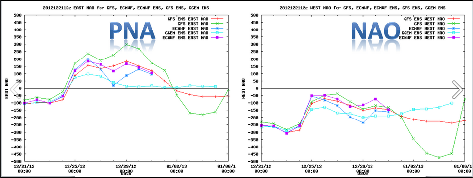
A little dip in the Jet stream will occur Sunday afternoon over the Mid-West tapping into a bit of Gulf of Mexico moisture and likely forming a weak surface low over Tennessee or Kentucky and then chug right through the Mid-Atlantic off the New Jersey coast and south of Southern New England Christmas morning perhaps bringing enough moisture on the northern flank to deliver a light accumulating snowfall to most our region. There is likely to be a few shifts in the precipitation shield and where the heaviest available moisture will fall due to a newly formed pattern just starting to take shape in the wake of today’s bizarre weather on the first day of Winter, with some respectable brief blocking in place. I will hold of on specific amounts for now, though a coating -3” is a safe call at this point if all pans out. We should clear out later in the day and remain quiet through most of Wednesday before we watch what could be or first official Major Winter Storm of the 2012-13 season sometime the late Wednesday through Friday time period. This one is being indicated as a phaser with Northern and Southern streams on model guidance and a Low coming out of the Gulf Of Mexico loaded with moisture and carry nothing with it but potential for intensification up the eastern seaboard. We have seen models do this before only to lose the solution just as quick though it coincides with a deeper set of support. That would be our teleconnections and specifically The PNA which is now showing signs over going positive for the 1st time in a while. The positive PNA is more likely to build a ridge over the western states which in turn develops a trough over the eastern states, and when you coincide that with a -NAO which often develops strong blocking near Greenland , it makes that eastern trough prone to become more amplified and more prone to the frequent opportunity of strong coastal storms/Nor’easters.
The all import block keeps for the most part strong Canadian High Pressure (cold air supply) locked to our north along the Maine and Canadian borders. This is why I feel a bit more confident in at least stating that our pattern change is starting to evolve now and fairly quickly. There still is likely to be mixing issues as there are with many if not all coastal storms, but its definitely a step in the right direction for snow lovers. More Info as it becomes available on this… Thank you for reading, and if we do not speak, a very Happy Holidays to all of you and yours. Oh,….NOW you winter lovers can start complaining if we see no snow. Its official ! ~Anthony
No comments:
Post a Comment