Tuesday, February 26, 2013

*NEW BLOG* Another Storm (Snow for some) On The Way

A major blizzard that just hit parts on the Texas Panhandle into parts on Oklahoma and Kansas is now tracking to the north/northeast as a strong “Cutoff” Low Pressure and is caught in a trapped 500mb pattern with strong upstream blocking near Greenland.
The storm is massive but not your typical coastal low or Nor’easter. Its center will sprawl out on its approach towards Southern New England this evening and through the day Wednesday as the low center will wobble and drift to our west through Thursday and possibly even into Friday keeping it unsettled, cold aloft and scattered mixed precipitation possible through the period and even into the weekend.
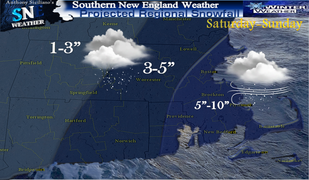
The main precipitation shield is now located still off to our south and southwest From Buffalo NY to southern New jersey and will continue to make its way towards our area this evening. Precipitation is expected to break out around midnight (give or take an hour or two) from the southwest to northeast. The air is initially cold enough aloft (850mb approx. 5,000 ft up) for all to support snow and mixed precipitation for many. This is the case also for those (which is many) that still have mild surface temperatures as dewpoints are lower in the 20’s to lower 30’s. The precipitation that starts to fall will lower the temperatures initially due to the lower dewpoints. This process is called evaporational cooling. The milder air aloft will begin to warm from south to north soon thereafter, though will take longer for the higher elevations and further to the north and west where our heavier snowfall amounts are expected with this storm. CLICK ON ALL GRAPHICS FOR LARGER VIEWS
Elsewhere after a brief burst on snow that could coat the ground for folks near the coast, this will turn into a windswept rainstorm with once again plentiful moisture and the potential for 1-2” on liquid with this one which looks to put many well above average for the month on February. The main batch of precipitation with this storm should start to decay after late Wednesday afternoon, though the Low pressure that is expected to stay to our west throughout that duration of the meat of the storm will start to drift towards the coast and with it bring back colder air aloft and could switch all to light snow and or snow showers that could be on and off throughout Thursday and even right into early Saturday, MUCH like our last storm. Some additional accumulations are possible with that as it could form yet another weak inverted trough or axis on heavy snowfall for some. That potential area is being monitored and hopefully can be pinned down in the next day or two. The other issue will be increasing wind gusts. The wind will increase near midnight with gusts near 30mph approaching the South Coasts and move northeast and increase to where many will see 35-45mph throughout the region Wednesday. Most of these gusts will be from the southwest initially then shift to the east and slight northeast. This adds issues to those that will see more snow as it is expected to be a very wet snow and certainly can’t count out some power outages near and especially outside of Worcester Massachusetts .
With that persistent gusty east wind, its the reason areas near coastal locations warm at all levels that this is predominantly a rain and wind storm. Any little accumulation that may occur in these locations will be washed away. High tide mid-day Wednesday may bring a storm surge on 1-2 feet to east coastal facing shores and possible minor flooding and erosion. Stay tuned for further updates as needed. Though not many expected as confidence right now is quite high on the solution just printed out. Thank you for reading ! ~ Anthony
For a mapped image and further details on all Watches, Warnings, Advisories and Hazardous Weather Outlooks for our area, CLICK ON THE LINK BELOW
http://www.erh.noaa.gov/er/box/

Thursday, February 21, 2013

UPDATED Blog : Storm Details...Winter Continues !

  For a third straight weekend a potential major Winter Storm will affect Southern New England. There remains no doubt that a storm will bring wintry precipitation to our area late Saturday through the day on Sunday. Storm details as of now are a bit sketchy though this thing will have plenty of moisture to work with feeding off upper level low energy over the northeastern Great Lakes and moisture sources from the Gulf of Mexico combined with Atlantic moisture being thrown into the primary storm that forms off The Mid-Atlantic late Saturday.
CLICK ON ALL IMAGES FOR FULL SIZE VIEWS
The Players: The piece of energy we are watching now is bringing wild weather to the midsection of the United States today and will move off  to the northeast as an Upper Level Low over the Great lakes. During that process sometime Saturday the energy and lagging moisture from that will form a primary low pressure somewhere between Cape Hatteras North Carolina and Southern New Jersey. THAT placement on where in the end that primary Low pressure forms is extremely important to this forecast. Either way the storm will travel to the NNE, then take a jog east in response to upstream blocking and a negative North Atlantic Oscillation. It will likely slow down a bit on its approach to southern New England and pass near our 40/70 benchmark and then make a pass close or southeast of Nantucket as a 998-990mb low. That is much weaker on a storm than the past 2 so damage hopefully will not be as bad . One thing with this storm as it has rich Gulf of Mexico and especially Atlantic moisture feeding into it, there will be a shot of warm air advection ahead and mixing issues and possibly lots of rain will be present near the coastlines, with potential for snow on front end and back end. That is how it looks just at this point. It is important though to remember as always that slight shifts will and could make a huge difference in both amounts on precipitation and precipitation for any given location geographically throughout Southern New England. Between a spread of operational and ensemble weather models , anywhere from ¾” - 2” of accumulated liquid precipitation can be expected at this time. Along with the precipitation, there will be the potential for a few strong wind gusts especially near the coast of eastern and southeastern areas.The heavy rainfall and especially areas with a deep snowpack still over coastal areas may bring some poor drainage flooding.A minor storm surge is also possible. Wave heights build to 10-20 feet off our coastlines.
How it should play out: Moisture levels in the upper atmosphere start to increase Saturday and especially Saturday afternoon ahead of our pending Winter Storm. We are likely to start to see mixed precipitation break out along the South coast and perhaps a plain rain there Saturday evening. That mix line could make it all the way up to the Mass Pike by late evening. From that point on it will begin to crash back towards the coastlines bringing a flip back to snow for many except extreme southeast Massachusetts and Cape Cod and the Islands.
All the meanwhile a heavy wet pasting snow is likely along and north of The Mass pike into Sunday morning with the heaviest shifting towards the east and northeast areas as low pressure moves off to the east and northeast on our area and a northeast wind will bring some enhancement to eastern , north eastern Mass and into the seacoast of New Hampshire. That area could be the “PivotPoint” zone where the snow hangs on a bit longer with NE fetch and blocking doing it think so to speak.
Winds not a huge problem though sustained winds will increase on the order on 15-20 miles per hour for central and eastern southern New England starting Late Saturday eve and likely sustained to near 25-35mph over Cape Cod and The Islands. Those winds continue right through at least the first half of Sunday before working offshore. Wind gust from late Saturday through Sunday will be on the order of 30-40mph favoring south and east of The Mass Pike and possibly as high as 50mph for Cape Cod and The Islands. While we have seen worse in recent storms it is certainly capable in combination on heavy wet snow expected and even heavy rainfall to saturate the ground/tree structure that some power outages are likely. With all this said, the coast looks to have mixing and or rain issues so accumulations held down low near these areas. Heaviest snowfall at this point is along and especially north of The Mass Pike into southeast New Hampshire where either side of a foot of snow could fall.

This is an initial snow map and further shifts remain possible and even perhaps likely with this storm. Also important to always look at the forecast range amounts .(my motto is low numbers likely-high ,possible). Precipitation ends later on Sunday and winds slacken and we are given a brief break on Monday and much of Tuesday before another potential Winter Storm almost similar to this one. That has potential for stronger winds and also a mix line.
Why all the storms as of late you may ask?. Well, the 500mb pattern has been conducive for development over the past 3 weeks or so and will continue to be right into March and beyond perhaps. Combine that with teleconnections all lined up for potential winter storminess. The AO is providing the occasional cold blasts with the PNA ridging out to the west in a positive phase occasional sending troughs across to the eastern U.S. and most importantly a negative NAO providing a Greenland Block and room for anything that touches the east coast to keep our area on our toes. Beyond mid week next, a cutoff low may form near or off our coast and could deliver multiple surges off moisture off the Atlantic for a couple to perhaps a few days and bring more precipitation and in the form of accumulating snow for many. Stay tuned and thanks for reading   ~Anthony

Friday, February 15, 2013

More Snow, Wind & Cold on the way... #Winter


Upper level energy and cold pool aloft over the northeastern Great Lakes will create deepening trough and low pressure to form off  The Mid-Atlantic Saturday afternoon. The Low Pressure Center is then forecast to intensify rapidly as its heads of to the northeast and is likely to make a pass east of the 40/70 Benchmark early on Sunday and head into The Gulf Of Maine as another likely sub 970mb low in a recent string of them.
  Many locations today in the 40’s to near 50° today and some may find it hard to see this occurring. Truth is the temperatures are the least of the forecasting concerns as VERY cold air aloft is accompanied by energy and dynamics aloft from the west-northwest and this will result in a dynamic cooling process bringing snow as the predominant precipitation type for many except perhaps brief mixing south and east for a time ,though feel even there in time it will be mostly snow falling.  Snow showers and a period of Light snow looks to break out as early as the pre-dawn hours of Saturday. This could bring minor snowfall totals before and during the morning commute on the order of a coating to 2" to perhaps an isolated 3”. This precipitation shield moves from southwest to northeast and brings a lull in the action for at least a few hours before that primary low pressure development occurs well east of  The Delmarva Peninsula Saturday late afternoon . 

CLICK ON ALL IMAGES FOR LARGER VIEW
In advance of that low pressure snow again looks to break out for many with the heaviest axis focused across central and eastern areas of Southern New England throughout the night and into at least most of Sunday morning dropping more accumulating snowfall before low pressure takes off with its moisture into the eastern Gulf of Maine. (important to ALWAYS look at forecast RANGE amounts they are there for a reason.. low-high number, or likely-possible).  Along with the snow potential is the potential for an extended period of gusty winds developing on Saturday and possibly lasting through Monday with occasional gusts on the order of 30-45 perhaps  50mph at times from the west/northwest and could cause a few more isolated power outages. Not what many want to hear again and also with an expected cold blast.  The other aspect of this and it pertains to the winds that will shift to the west, northwest is how biting cold it will get through the day Sunday with falling into the 20’s for many and with those guts, wind chill values may dip near 0° or even well below for many. The wind and very cold air and low wind chills lasts right into at least early Tuesday.

Beyond this system, maybe some overrunning precipitation on Tuesday and perhaps icing for some. Beyond that, blocking will remain with a predominant negative North Atlantic Oscillation and a 500mb pattern that favors an amplified eastern US trough. That combined with multiple surges of moisture coming out of the Gulf Of Mexico, it appears a very active mid to late winter pattern is likely to shape up.    ~Anthony

Thursday, February 14, 2013

Graphical Storm Potential This Weekend ..Blog This evening.

Graphic represents the greatest probability of accumulating snow at this point though there are finer details in timing and especially amounts which hopefully become more clear through the evening and night and into Friday..As time and confidence warrants amounts will be plugged in.. a blog post is scheduled for this evening..Stay Tuned