
Upper level energy and cold pool aloft over the northeastern Great Lakes will create deepening trough and low pressure to form off The Mid-Atlantic Saturday afternoon. The Low Pressure Center is then forecast to intensify rapidly as its heads of to the northeast and is likely to make a pass east of the 40/70 Benchmark early on Sunday and head into The Gulf Of Maine as another likely sub 970mb low in a recent string of them.
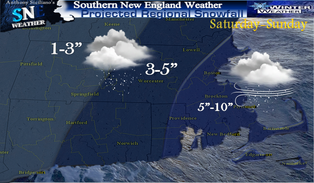
Many locations today in the 40’s to near 50° today and some may find it hard to see this occurring. Truth is the temperatures are the least of the forecasting concerns as VERY cold air aloft is accompanied by energy and dynamics aloft from the west-northwest and this will result in a dynamic cooling process bringing snow as the predominant precipitation type for many except perhaps brief mixing south and east for a time ,though feel even there in time it will be mostly snow falling. Snow showers and a period of Light snow looks to break out as early as the pre-dawn hours of Saturday. This could bring minor snowfall totals before and during the morning commute on the order of a coating to 2" to perhaps an isolated 3”. This precipitation shield moves from southwest to northeast and brings a lull in the action for at least a few hours before that primary low pressure development occurs well east of The Delmarva Peninsula Saturday late afternoon .
CLICK ON ALL IMAGES FOR LARGER VIEW
In advance of that low pressure snow again looks to break out for many with the heaviest axis focused across central and eastern areas of Southern New England throughout the night and into at least most of Sunday morning dropping more accumulating snowfall before low pressure takes off with its moisture into the eastern Gulf of Maine. (important to ALWAYS look at forecast RANGE amounts they are there for a reason.. low-high number, or likely-possible). Along with the snow potential is the potential for an extended period of gusty winds developing on Saturday and possibly lasting through Monday with occasional gusts on the order of 30-45 perhaps 50mph at times from the west/northwest and could cause a few more isolated power outages. Not what many want to hear again and also with an expected cold blast. The other aspect of this and it pertains to the winds that will shift to the west, northwest is how biting cold it will get through the day Sunday with falling into the 20’s for many and with those guts, wind chill values may dip near 0° or even well below for many. The wind and very cold air and low wind chills lasts right into at least early Tuesday.

Beyond this system, maybe some overrunning precipitation on Tuesday and perhaps icing for some. Beyond that, blocking will remain with a predominant negative North Atlantic Oscillation and a 500mb pattern that favors an amplified eastern US trough. That combined with multiple surges of moisture coming out of the Gulf Of Mexico, it appears a very active mid to late winter pattern is likely to shape up. ~Anthony
No comments:
Post a Comment