(CLICK ON ALL IMAGES FOR A LARGER VIEW) It will be nice to wake up Saturday to a classic New England Snow Sky and that distinctive smell only sensed by die hard New England Winter lovers (if you like snow!). It sure has been a while for many and this one should deliver. Snow looks to develop (lightly at first) Mid-morning to the west and south and make progress off to the north and east thereafter. Be advised but not surprised or discouraged if you start with a few raindrops.
Though I just do not see that happening for too long if at all with such cold air aloft projected. Snowfall will increase in intensity as the low pressure nears from our south and eventually looks to pass just southeast of The 40/70 benchmark and pass off to the northeast of Southern New England Sunday morning with some backlash snows and ocean enhanced snows falling along east coastal area’s.
This track is just a bit farther south than the last storm and makes all the difference in the world this time with ample cold air aloft to support a snowstorm for many folks. The area highlighted to received the most snow is Norfolk , Bristol and Plymouth Counties in eastern Massachusetts away from the immediate coastlines as well as central and northern Rhode Island and northwest Connecticut . Locations along the IMMEDIATE coast will be fighting marginal temperatures and dewpoints at the surface . The hope is the intensity will help drag down the colder air aloft (850mb temps) for a snow pack all the way to the Cape Cod Canal and perhaps a bit beyond.
<<<850 mb TEMPERATURES
The rest of Southern New England is in for a widespread 3-6” of snow with this one, and for that Winter Weather Advisories are in place for all, with Winter Storm Watches in place over the favored higher prone areas. The reason for the higher amounts east is the closer proximity to the storms center and temps and dewpoints optimal for a snow growth region. Also often times in these events a coastal front forms from Gloucester Ma-Plymouth-The Cape Cod Canal and snowfall just to the west of this front becomes enhanced as well as enhancement from the ocean from a LIGHT northeast wind fetch…Key is LIGHT, so it does not pull the milder air in from the Atlantic Ocean, so that is what is forecasted as the Max Zone. This is a fairly quick hitter and is out of here by dawn on Sunday, with perhaps a few ocean effect snow showers affected extreme eastern areas and Cape Cod on a north wind. The snow that falls appears to going nowhere fast as the very cold air rolls in behind from southeast Canada and will be going nowhere fast as well. In fact it could be the coldest first week of January for some dating back to 1996 ! It will go from 30’s to highs, to 20’s to teens for some through the first days of 2013. Far cry from non-winter last year eh!? The active pattern will take a breather with the renewed cold as it will be “Too cold to snow”. Thanks for reading and have a wonderful weekend Anthony

Abnormally mild temperatures and much needed rainfall today for many throughout Southern New England was good to see as we are almost at normal precipitation levels now for the month of December with more shots coming ahead. The wind was really whipping out there with gusts reported 35-60mph region wide with Category 2 force Hurricane conditions atop the Summit of Mount Washington New Hampshire for a time with a strong low pressure system passing over western Vermont. Much colder air is filtering in now behind our storm system. There is still a large cyclonic flow over the region and lots of cold air aloft streaming in as well, this will set up for temperatures to drop this evening and not recover to much if not at all Saturday under mostly cloudy skies with some partial sun certainly expected. That sun could bubble up some cold air induced instability clouds which could drop a few snow flakes, or rain showers. This process could occur a few times throughout Saturday , especially the interior of central and western Southern New England. Beyond Saturday High pressure takes control bringing quiet and cold weather for Sunday and most of your Christmas Eve Day.
Sure by now you have heard me mention the possibility of a White Christmas still exist and that holds no more true than today as our guidance is trying to pull a rabbit out of its hat. Sure, some may be thinking models have all shown this before under great agreement only to fail in the end. Well it goes further than that beyond both operational and ensemble guidance, and especially after Christmas. As far as the snow possibility Christmas Eve into Christmas Day, it is noted right off the bat that there will not be a lot of moisture available and this does not look like a big deal at all. It will be a big deal if many wake up to flakes falling though for sure and maybe a sign off things to come and put a smile on a few faces.
(Click on graphic for larger image)
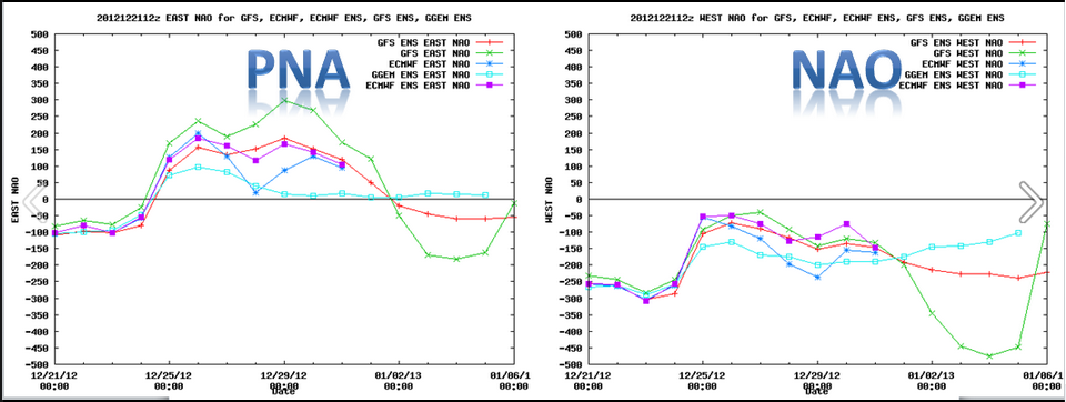
A little dip in the Jet stream will occur Sunday afternoon over the Mid-West tapping into a bit of Gulf of Mexico moisture and likely forming a weak surface low over Tennessee or Kentucky and then chug right through the Mid-Atlantic off the New Jersey coast and south of Southern New England Christmas morning perhaps bringing enough moisture on the northern flank to deliver a light accumulating snowfall to most our region. There is likely to be a few shifts in the precipitation shield and where the heaviest available moisture will fall due to a newly formed pattern just starting to take shape in the wake of today’s bizarre weather on the first day of Winter, with some respectable brief blocking in place. I will hold of on specific amounts for now, though a coating -3” is a safe call at this point if all pans out. We should clear out later in the day and remain quiet through most of Wednesday before we watch what could be or first official Major Winter Storm of the 2012-13 season sometime the late Wednesday through Friday time period. This one is being indicated as a phaser with Northern and Southern streams on model guidance and a Low coming out of the Gulf Of Mexico loaded with moisture and carry nothing with it but potential for intensification up the eastern seaboard. We have seen models do this before only to lose the solution just as quick though it coincides with a deeper set of support. That would be our teleconnections and specifically The PNA which is now showing signs over going positive for the 1st time in a while. The positive PNA is more likely to build a ridge over the western states which in turn develops a trough over the eastern states, and when you coincide that with a -NAO which often develops strong blocking near Greenland , it makes that eastern trough prone to become more amplified and more prone to the frequent opportunity of strong coastal storms/Nor’easters.

The all import block keeps for the most part strong Canadian High Pressure (cold air supply) locked to our north along the Maine and Canadian borders. This is why I feel a bit more confident in at least stating that our pattern change is starting to evolve now and fairly quickly. There still is likely to be mixing issues as there are with many if not all coastal storms, but its definitely a step in the right direction for snow lovers. More Info as it becomes available on this… Thank you for reading, and if we do not speak, a very Happy Holidays to all of you and yours. Oh,….NOW you winter lovers can start complaining if we see no snow. Its official ! ~Anthony
(CLICK ON ALL GRAPHICS FOR LARGER VIEW) A Blizzard is underway ! Just not here in Southern New England as many would wish, while others are just fine with this somewhat mild (depending on exact location) and breezy weather as of late. While in the long-range, there appears to be no major shift to the current pattern that has evolved over the past week or two which send most storms over or to the northwest of our area, there will be a few wrinkles in it that maybe cold enough and just at the right time to produce some wintery weather for us depending on storm development and the track and redevelopment potential as always.
Thursday looks very nice by mid-late December standards with a chilly morning start and perhaps some ocean effect clouds on Cape Cod with a few rain or snow showers early. For the rest of our area we will see sun and clouds with light winds and temperatures right around where they should be this time of year in the upper 30’s to low 40’s on average. Enjoy the peaceful day because Friday some big changes come in.

Friday as a strong low pressure system spins over the eastern Great Lakes , a new low will form near or over New England. This is a POTENT front passage and one that will bring with it a burst of strong to damaging winds, showers and downpours with the potential of a thunderstorm to our area. A Thunderstorm you ask? On the first official day of Winter?. That’s right and you don’t have to look far back to see the last time that occurred because it happened last year on December 21st. What an extremely odd coincidence, and may add new meaning to the term Starting off Winter with a “bang“. Behind the downpours, wind and potential thunder, temperatures will begin to crash as the winds shift behind the departing low and perhaps bring a quick change to snow western and central areas before most the moisture escapes to our north and northeast Friday evening.

So here are the finer details as I see them shaping up on Friday: Mainly light showers come in well ahead of the front before dawn Friday to southwest areas of Southern New England, progressing steadily to the northeast there after. Most the area will be in showers/downpours early afternoon ir late morning with perhaps a thin convective line affecting our area around or shortly after noon time that will bring strong to perhaps damaging winds gusting 45-55mph, perhaps a bit more. If we hit 60mph in any gusts associated with the downpours of thunder, a isolated Severe Thunderstorm warning cant be ruled out. (Bizarre) After that line crosses with the front we wil go into the dry sector before the cold air starts to charge in here from the WNW as the main vortex off to the west swings on though bringing with it MUCH colder air. Most in our area will see ½ -1’ of rain with a good possibility of a bit more throughout the SNE region.

Cold air comes pouring in starting Friday night both at the surface and especially aloft as the Vort max swings through and sets the stage with still a broad cyclonic flow over our area for the potential of snow flurries and snow showers falling for many on Saturday along with temperatures that will continue to fall on a breezy active WNW wind still. Remember entering in Winter with a bang?, well that is what might occur quite literally as this cold will stick around for a few days it appears.
The storm that exits Saturday will set off/up a trough near or just offshore into the late weekend and towards Christmas Eve. At the same time , a weak low may ride the trough and bring the shot and a bit of light snow to fall into Christmas Day ! Though please do not get hopes TOO high for that as most the time in that situation moisture stays suppressed to the south. Will certainly be keeping an eye on that along with signs now that the pattern will remain active but now possible with just enough cold air to our north to make it interesting. Our teleconnection indices remain fairly supportive of stormy weather with the North Atlantic Oscillation projected to remain negative along with the PNA steadily rising. Speaking of up north. Maine continues to be ground zero for snow as of now. Some mountains up there have already picked up FEET of snow and the Friday storm we should keep adding to those. That snow pack is important and will continued to be monitored. Thanks for reading. ~Anthony
If you missed its release Tuesday, Here is The “Southern New England Weather Probability of a White Christmas” this year
As we wrap up a quite extended period of dry , above average temperature period of early December, a very active period of weather awaits for much of next week starting Sunday and also shows signs of this continuing right through much of December. Most this next week will be too mild in Southern New England for any snowfall of significance though very cold signals are being indicated starting next weekend and beyond. Below I will break down each event scheduled for the week and what may lie ahead as we welcome in the official Start to the Winter Solstice next weekend. (CLICK ON GRAPHIC FOR LARGER IMAGE)

Storm/Event One ..Sunday-Monday : Clouds and overrunning moisture will increase across our area this evening into the overnight as Low pressure now over the western Great Lakes moves towards our area Sunday. As it does so a new Low will form south of Southern New England during the morning hours of Sunday. There will be cold air that will be tough to budge initially so expect some light snow to break out for most our region after mid-morning . Those closer to coastal location may see a brief period of snow that will transition through some sleet before completely over to rain not long after. Further inland , the light snow burst and sleet combination will persist longer and the cold holds firmer for a longer period of time. Dry dew points in the interior will help in this as well with Evaporational Cooling expected as precipitation begins to fall, a brief drop back in temperatures is likely to occur. For this reason, we may see a few Winter Weather Advisories pop up Sunday Morning . There also is the likelihood as temps warm aloft as the precipitation enters that the snow/sleet combination inland may turn to a period of Freezing Rain before the eventual transition to rain as all layers warm by evening time. The most snow will fall in the Northern Berkshires of western Massachusetts and along the border of Vermont into southwest New Hampshire where 1-3” appear likely with a few locations possible to see a bit more depending on how long temps aloft stay cold enough. This should be until approximately 7pm Sunday evening. Precipitation is likely to come to a brief end during Monday morning before the next wave of low pressure approaches from the west/southwest

Storm 2 Monday pm through Weds: This storm will have a bit more juice with it but also have warmer air incorporated into it as it approaches and already mild air in place upon its arrival. Most of this storm will be rain, heavy at times and gusty winds from the east/southeast into the shores as Low Pressure is expected to pass right over or just off the Southern New England Coast. Important to note there still is minor disagreement on the eventual track and potential redevelopment of a new low off the Mid-Atlantic coast. Though most indications are a breezy Rainy event with possible mixing along or near the Route 2 corridor into southern Vermont and New Hampshire . This storm may carry the potential of some minor coastal flooding and beach erosion as well. Colder air will be pouring in briefly on the backside as the storm passes off to out NNE so there is a slight shot at a switch over to a period of snow. Will continue to keep eye on that.

Storm 3 Potential Friday through The Weekend: There is a 3rd storm potential which in the end could end up being the most potent out of the bunch. This storm , again is highly dependant on the track. Behind storm 2 , colder air will pour in so that complicates issue farther. More snow potential with this one, again especially across the interior. This system is 5-6 days away and lots of time for a different pattern to become establish due to the prior two storms. Little side note: Portions of Maine are in for 1-2 Feet of snow, perhaps near 30” for some through this period…Lots of Juice !
Beyond this , current indications are the coldest air of the season pours in and perhaps sets the stage for snowstorms for our area as we officially welcome The Winter Solstice in Here Dec 21st. One model shows a Christmas Eve-Christmas Day storm with another very potent coastal storm coming in December 27th.
So, though we saw a few minor snow events in November into early December, we have been dry and mild as of late leaving many asking “where is Winter again“? “Will this be a repeat of last year ??”… Lets let it officially start first ! How does that sound?. Also, if your worried that all this rain means it will continue through Winter, that’s simply a gut feeling and not true at this point. Back in December of 2010 a HUGE rainstorm occurred mid-month. After that, Winter arrived in a BIG way and we never looked back….No Panic yet snow lovers.
Quiet mild weather has prevailed for the most part through much of December so far with a few periods of rainfall that have not even begin to put a dent into what will end up a WELL below normal year for precipitation as some are running as much as 9” below normal. It remains no doubt that we are in desperate need of precipitation badly. Its not in the cards for the next few days as High Pressure looks to keep us right around seasonable for this time of year and dry. I am watching a potential storm system for late this weekend into early next week that could make for a snowy scene Sunday as the San Francisco 49er’s come to Gillette Stadium in Foxboro. I’m sure you have heard, ( hopefully from Southern New England Weather ) that a pattern change appears in the works and signs continue to indicate so as The Projection of The North Atlantic Oscillation (NAO) continues to drop along with the potential rise in the Pacific North American Pattern (PNA).

Both elements indicate colder and stormier times lie ahead between now and at least December 27th. That along with finally a loosening grip of domination with the Northern Jet stream which has sent mild air ahead of cold fronts as storms arrive passing to our northwest, seems to be weakening and a more active Southern Jet stream is prone to take over bringing deeper moisture into storms potential tracking up towards the N. East Coast from the Gulf of Mexico and the Southeast united States. The 500MB pattern also suggests this and has for quite sometime regardless of all the Mid-Long Range outlooks that have been floating around now and then for above average temperatures for much of the United States. All reality is that the signs have been consistent just the opposite for some (SNE) and now our Ensemble and Operational weather model guidance is starting to come around late in the game. This is not a surprise though as confidence in weather models always is lower the further out in time and increases as time draws near. This is especially true when other factors disagree amongst each other, ie. Blocking, lack of pacific Northwest data, ect., ect. As far as specific dates and amounts for specific locations, that remains unknown this early in the game, though there is increasing confidence in a weak storm system approaching from The Ohio River Valley late this weekend and a marginally cold air supply parked off to the North of New England in southeast Canada. This should spell out light wintery precipitation coming in late Sunday, possibly becoming a bit enhanced approaching Southern New England early Monday along with a weak trough that could keep lighter precipitation falling in eastern areas. The potential is there for a few inches of snow with this one. Not a blockbuster though as there will be no phase with the Southern Jet Stream. That could change as we approach the mid-later half of next week as a ridge will build near The Four Corners and send a deeper trough , tapping into Gulf of Mexico moisture and sending a strong surface low up the eastern seaboard with a -NAO (Greenland Block) in place. That storm appears around the 19th-22nd timeframe and looks Juicy !
 The Official Start to the Winter Solstice is Saturday of next week and we may coincidentally be just getting it going. ~Anthony
As we close the door on a very dry , below normal temperature wise November, ( November SNE data ) we now have opened the door to a somewhat wintery start to Meteorological Winter and December. Many locations across Southern New England this morning were greeted to light snowfall and widespread coatings across the region along with unseasonably cold temperatures. Almost like a script right ? Well it certainly will not last long as winds will shift overnight and into Sunday from the south and slightly southwest with high pressure settling further to the south and push a warm front north into and through the region and bring us well above normal for this time of the year in the 50°’s ! That should last until early Wednesday before a strong cold front will bring couple downpours or even a rumble of thunder with a uick switch to snow on backside central and western SNE Wednesday afternoon and much cooler weather back where we should be this time of year to follow.

Signs are "back" (a bit delayed) that upstream blocking near Greenland could again try to re-establish itself along with a disintegrating massive low over the Gulf of Alaska finally leaving that area and a Polar Vortex over central Canada that has been stubborn to budge, finally start to make the track South/Southeastward towards the lower 48. All this potentially indicates a cooler and stormier pattern setting up in the mid-term and especially after December 9th time frame . One of our reliable models indicates a Nor’easter around that time with interior snow, a coastal mix and strong winds. This is something we will watch over the coming days and bring further updates as needed. A combination of that model and another long range model indicate the storminess may not stop there as blocking tries establishes often in the upper 500mb pattern and a recent dominating Northern Branch Jet Stream begins to shift southwards and allows for phasing with the Southern Jet Stream which has lacked so far with cooler air in place though has occurred back in late Oct and Nov with Sandy and the Nor'easter respectively. This increases large storm potential greatly for The Mid-Atlantic and Northeast. Its still has to come together though as it has potential to do so with key factors en route perhaps, but certainly not a given. It will be something to monitor and can be nothing but better news ahead for Winter lovers.

So Enjoy the mild air and break next few days and for the winter /snow lovers, time to get down and dirty. Thanks for reading. ~Anthony