

The storm will continue to move off to the NNE and pass near or over benchmark 40/70 Wednesday evening. Meanwhile high pressure will be parked off to the north of New England along the Canadian. US border. That as you know means trouble most the time
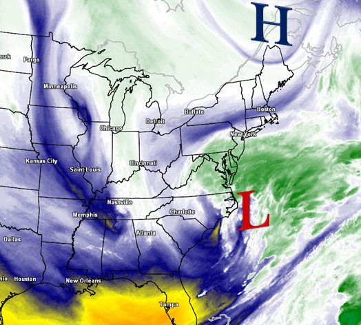
. There are a few wildcards with this one. Very marginal cold support from 850mb temperatures. With them being marginal, in order for widespread snowfall, precipitation would have to come down at a heavy rate to “tap” into the colder air aloft. Right there, this setup favors higher elevations. The precipitation portion of this storm will likely be unknown right up to the last minute honestly though the potential is there for snowfall almost right to the coast. This does not seem likely to me at this point. Though from Worcester MA points west up and down SNE, it is. Also there is the chance of some freezing rain which could occur after an initial burst of snow across inland areas.

This is due to models indicating a spike in temperatures aloft while surface temps remain at or below freezing for some. Dewpoint and wet bulb temps will need to be monitored very closely just prior and during the storm. In spite of that, I think most all transition to rain except those above 800-1000 ft. When night falls Weds eve, some could go back to snow. It all sounds like a lot, though in reality there is not much moisture to work with in this storm. Western SNE looks to see about a ½” of Precipitation and those numbers could increase to near 2” on Cape Cod & The Islands. The BIG story with this storm will be the winds. They will start to increase from south to north during the morning and reaching sustained speeds of 20-40 MPH from NW-SE by the afternoon. Wind gusts will begin to approach 30-35mph across the interior, perhaps some near 45mph. Gusts closer to the coastline are likely to exceed 50mph with some near or over 60mph !. For this potential, High Wind Warnings and Wind Advisories have been posted by The NWS.

There also is potential for minor to moderate coastal flooding and possible beach erosion. Best guess on timing is as follows : Precipitation likely to start from S-N during mid morning Weds, ending Thurs mid morning, perhaps earlier. The winds will be steadily increasing come Wednesday morning and maxing late night and calming down early Thursday afternoon, though still remaining breezy. So, This is you typical Nor’easter. Unfortunately it come just over a week removed from the worst storm many in the Northeast have even experienced. My thoughts and prayers remain with those who lost love ones, are displaced and with out power. Its going to be cold ! Good news is with block releasing a bit and a huge ridge building to our west, we will turn mild early next week. But, guess what?….The block will be back…..That’s it for now , thanks for reading ! ~Anthony
No comments:
Post a Comment