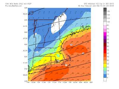
The good thing with this storm coming is that there is zero doubt this is a "snow" storm. Very cold temperatures will be in place at the start and hold , maybe even drop throughout the event. This is important for a few reasons, 1: The snow will add up as its falling, there will be no wasted precipitation. Snow ratio's appear to be near 20:1 perhaps more ! This is due to temperatures being only in the teens to 20's at best for many during the storm, perhaps colder. This creates a fluff factor. The bad thing to that is that with expected gusty winds at times especially neat the coast there will be blowing and drifting of snow at times. Even though it appears the snow will never really "puke", its a drawn out light to moderate perhaps heavy at times intensity to it. The blowing will create low visibility at times for motorist. Something to be aware off. This looks to be the case especially for eastern Massachusetts and Cape Cod and the Islands as that will be the area of strongest winds and still a fluffy snow.
The other issue with this storm and again especially eastern Mass. shorelines and the Cape and Islands is the potential for coastal flooding during the Friday Am high tide cycle. Winds look to be sustained out of the north/northeast between 30-perhaps as high as 40 mph for a time early Friday morning. Given this flooding could be moderate. Again, this really does NOT hinge on the placement /intensity of storm, its likely to occur regardless.
So how much, right? I am not going to go crazy with this but looks like a general 8-12" snowfall for the region with potential for a few places to see over a foot favoring areas of eastern Ma and RI as this area will be under the influence of a NNE (seen in wind graphic above) wind flow and with relatively mild water off the coast it acts to enhance snowfall in those areas as we have seen many times before. "Ocean Enhancement".
Here is my overall thinking. As always I urge you to look at the forecast range and not just fix to the high number. light snow starts Thursday morning. Heaviest period is late night into early Friday with light snow continuing to the east for much of Friday as well. In its wake we are left with frigid arctic air with temps below zero (some *well* below ) for much of the region both Friday and especially Saturday morning. The potential is there for another storm Sunday night and Monday. Still kinks to work out with that one. Thank you for taking the time to read the blog and Happy New Years !! ~Anthony


No comments:
Post a Comment