Alberta Clipper Approaching. Details & Whats Ahead...
Click All Images For A Larger View....Two days removed from the first significant winter storm of the 2013-2014 season and now we are watching yet another system approach us this eve as northern branch energy dives east/southeast from central Canada currently north of Lake Superior. This energy/weak broad low pressure continues approaching southern New England this eve spreading a swath of light snow along the way. It's the ingredients for what we call an "Alberta Clipper". These clippers have a history of being moisture starved and usually drop minor advisory snowfalls and for many that is exactly what this one will do. But wait, we are still left in the same Jet Stream pattern just a few days ago and enough tilt to the Jet Stream that once that energy/vorticity nears the eastern shores of New Jersey it will spawn a secondary, coastal low off south of Long Island and start to intensify as it passes just east of the southern New England coastlines Tuesday evening. It is the formation of that new low pressure system in combination will remaining arctic air to the north being drained into the storm. This is the set up that brings us our accumulating snow for Tuesday.

If you are thinking that it seems like a while since we have seen one of these buggers, It has ! I don't have any specific dates but can tell you its been at least 2 yrs. Again, not a huge deal here but the timing could be rough for the evening commute as it is likely that moderate snow will be falling especially closer to Boston - Providence to the north /northeast into southeast New Hampshire. It is that area along with some favored higher elevations that could approach warning criteria snow of 6"/+ as this will be the area of greatest dynamics and lift being close to the center of a developing low pressure. In the image below the surface pressure trend /change shows falling pressure off the area of expected development during the mid to late morning hours.

At that time we will start to see more organized bands of snow closer to the coastlines. The storm is all snow for all the area except south and east of the Cape Cod Canal and the Islands as they will be close to the developing low which in turn allows milder air to come in off the Atlantic a bit of mix/rain *could make it as far north as Plymouth, Ma. Areas west of RT 24 in eastern Ma will see a dry fluffy snow. It is important to note with the cold temperatures as of late that the snow will start to adhere to all surface immediately. This storm is another quick mover with once again a lack of upstream blocking near Greenland (-NAO) , so may catch a few by surprise during the late afternoon, early evening hours as it progress off to the ENE. The concern is that the strongest part of the event commute during the Pm/evening commute. There are signals from guidance of steep mid level lapse rates (change in temperature of height) these values tend to lead to heavy convective-like precipitation and banding and yes even the potential for a rumble of thunder ! Something to monitor while now-casting early tomorrow and something to keep in mind if venturing out that you could get caught in a low visibility situation in heavy snowfall especially from Providence to Boston to southeast New Hampshire . The light snow starts to spread in here during the mid morning hours first in SW Connecticut and then will advance to the NNE thereafter reaching the eastern shores by 11am give/take.

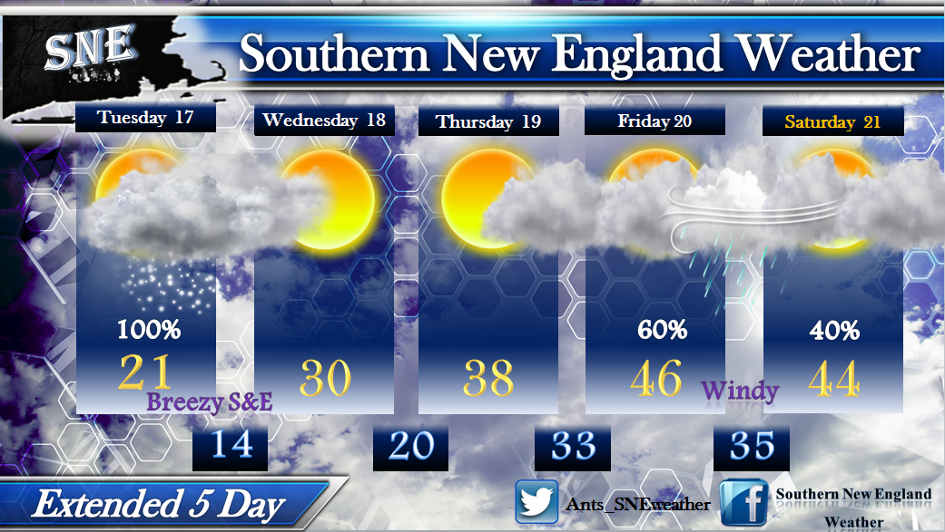
The other thing to watch for is some gusty winds to develop over Cape Cod & the Islands. Gusts 25-35 mph are possible into Wednesday morning. Its a cold day ! Highs only in the Teens for some , 20's for most and 30's over extreme southeast MA , the Cape & Islands. Wednesday we are left with some lingering morning clouds east before sunshine develops and we approach 30° for highs as a SNE average. The Warming trend will continue throughout the week with lots of clouds around after Thursday into the weekend , but mild ! Highs will be near/into the 50's possibly on Friday with windy conditions at times and showers developing late.

It appears as though the big trough driven by the Canadian Polar Vortex will work offshore towards Thursday allowing for an eastern ridge to build and bring the mild, showery conditions right into the weekend as well. Fear not though snowlovers...We need this to reshuffle things in the atmosphere and already there are indications the cold comes back in time for Santa and perhaps a storm system to watch as well. Thank you for taking the time to read the blog, I appreciate it. ~Anthony Oh..Winter begins Saturday ! Yup, has not even started yet.


No comments:
Post a Comment