
Its not quite "Winter" just yet but try telling that to Mother Nature. The active early to mid December pattern will roll on. It looked much different with the first few days of December in Southern New England averaging above normal temperatures but since we have been going nowhere but downhill and looks to be no prolonged end in sight to the cold. The change in the pattern started in its early stages towards late November and is continuing to date. It has been an impressive cold and snowy start to the season across much of the United States with relentless arctic air in the west and a nation that is now left with the highest percentage of snowcover to date going back to at least 2003.

This storm will come with snow, heavy at times, some mixing near the shores and also some rain over far southeast SNE. The heaviest axis of most snow like many set ups like this occurs just to the north/northwest of the big cities as colder temperatures will bring in the "fluff factor" there even though less moisture may be in the cards for them as opposed to locations nearer to the coast. The coast will see a wetter type snow and possible mixing at times. A situation seen many times before and the snow map will echo that likelihood. In the below image of a snapshot of the current Water Vapor, you can see the ingredients coming together now for the storm ahead. First the northern energy now diving into the northwest US from Canada and building moisture over Texas which will soon tap the Gulf Of Mexico. These two meet up over SNE on Saturday , clash with large arctic high pressure to the north to bring us our winter storm/ Nor'easter. The included model image shows the idea of how it comes together as well.

Its still a tad too early to really get into specifics as far as timing and such but light snow looks to break out for most as early as 10am Saturday morning and will spread and intensify thereafter from SSW-NNE. The brunt of the storm comes Saturday evening into the first part of Sunday morning before tapering precipitation towards Sunday afternoon. Along with the Snow, mix and even rain for some mixing near the shores will come winds, especially but not confined to the eastern shorelines of SNE. Sustained ENE winds will develop between 20-30 mph for favored locations which the model image below gives a general idea. Wind *gusts* across much of SNE will be on the order of 30-40 mph for some and perhaps briefly approach 50mph for the Cape & Islands as the storm intensifies Sunday am off the coast heading into the Gulf Of Maine.

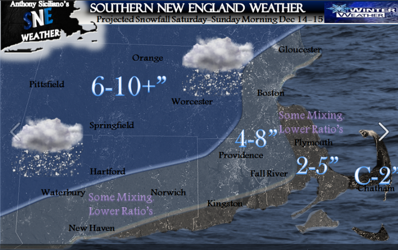
Waves 7-10' will develop just offshore of east and southeast facing shorelines and in combination with the expected winds may cause some splash over and minor coastal flooding at the times of high tide Sunday morning. So to wrap up , when all said and done the largest most impactful winter storm of the season is on the way and here is the expected snowfall map through early Sunday afternoon.
As far as where we are headed beyond this weekend I feel our active/COLD pattern will continue into at least next week. I am monitoring the potential for more snowfall early to mid next week along with possible record cold temperatures especially early in the week. Then Winter starts officially. Enjoy. ~Anthony
Quick Note: A few more finer details may arise and minor changes. Stay tuned to twitter and my SNE FB Fanpage for any further developments. Thank you for taking the time to read the blog.
I think this storm is going to exit our area by Sunday morning. I believe it will be a fast moving storm.
ReplyDeleteMichael Amato