Thursday, January 31, 2013
Wild Winds, January Is a Wrap. Back to Winter !
CLICK ON IMAGES FOR A LARGER FULL SIZE VIEW
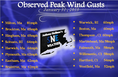
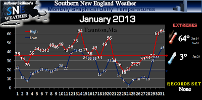
We just wrapped up a wild night Wednesday and a wilder early Thursday morning with widespread winds gusting 50-60mph with many locations reporting gust near 70mph or more ! In fact Blue Hills Observatory (elevation 635 ft) reported an unofficial gust to 81mph and was greater than that at any time during Super Storm Sandy back in October and was the worse winds the " Great" hill had experienced since 2006 as a whole. Very Impressive for sure ! All the ingredients had come together as forecast at the perfect time to create the damaging winds with an intense screaming Low Level Jet Stream just above our heads of more than 100mph. Thin convective lines of precipitation swept through the area aiding in bringing some of those gusts in modified form to the surface. Hence all the wildness and constant roars and howling that I’m sure kept many in Southern New England up for a good portion of the night and early morning hours. Accompanied by the winds were some heavy downpours and even some thunder reports in southwest Connecticut and parts of eastern Massachusetts. Many folks saw between a half inch to as much as just over an inch of rain. It was much needed at right at the last second, though many locations if not all will end January well below the norm for the month. Temperature soared ahead of the winds and rains into the 50’s and 60’s for many. Worcester , Ma. set a NEW daily record high temperature on Wednesday of 56° smashing the old of 53° from 1938, and also set a NEW daily record high Thursday of 59° beating the old of 57° in 1988. Windsor locks in Connecticut also set a daily high Wednesday also of 61° topping the old of 59° set back in 1947 .This January sure was bizarre. I'm not sure in the years I have been doing climate graphs that one has looked quite like this.
All that warmth is now a distant memory as the low pressure that brought the wind, rain and warmth is now over southeast Canada intensifying now to near 950mb ! On the back side, winds are now from the west and or northwest ushering in much colder weather from here on out. We have even seen light snow reported across western Massachusetts and flurries reported throughout other areas of Southern New England Thursday afternoon and evening as some massive Lake Effect Streamers approached and broke off into our region. Winter is back after a short reprieve for sure. A weak shortwave passes to our south Friday morning, though the cold blast of drier air keeps most moisture at bay except for a few clouds especially south and east. An Ocean Effect light snow shower may pop up over extreme Outer Cape Cod . Along with also a few higher elevation snow showers for western Massachusetts and the Northwest hills of Litchfield county Connecticut . Other wise Friday is much colder and breezy with highs only reaching in the upper 20’s and 30’s region wide. Saturday looks quiet and again colder again upper 20’s and 30’s expected.
Sunday we watch for a couple scenarios that may develop to bring a light to perhaps moderate worse case scenario snowfall favoring locations closer to the coast once again. Scenario one: Energy and moisture from an Alberta clipper approaches Sunday afternoon as a new low center forms offshore and once again the potential for an inverted “Norlun” trough becomes established. The location of which would favor a corridor from southwest Connecticut to down east Maine, zoning in near east coastal to northeast Massachusetts and southeast New Hampshire. Or, scenario 2 : The clipper energy swings south and a primary low pressure forms well near or southeast of the 40/70 benchmark and all of central and eastern areas of SNE get brushed by an intensifying coastal storm before it moves off to the northeast into the waters of the eastern Gulf of Maine . Both scenarios at this point favor coastal locations though a trend further west cant be ruled out nor can a complete miss which would not shock me either. A couple more clipper systems swing through/south of us next week also and bear close watching. More updates will be released tomorrow as needed. Thanks for reading, hope you enjoyed a completely whacky January and are ready for what February has to offer. It has a history of being dramatic at times . Buckle up ~Anthony
Subscribe to:
Post Comments (Atom)


Nice Job Anthony , Norlun Trough's Wx definition, A System in which Meteorologists do NOT have a friggin clue...lol
ReplyDeleteThank you, they are actually ready for me to pick up on models...though even to last minute can set up anywhere, even Just offshore and bring nothing. But they are predictable imo
ReplyDeleteThank you, they are actually ready for me to pick up on models...though even to last minute can set up anywhere, even Just offshore and bring nothing. But they are predictable imo
ReplyDeleteSo 7 hours into the storm and we have 2 inches in Haverhill. Let's hope this is not a bust.
ReplyDelete