

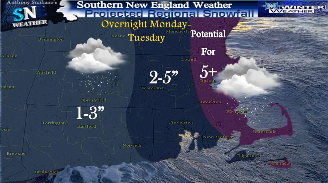
We saw a fairly nice mid-January day out there Saturday in the 40’s for many, though gusty winds did not make it feel as mild, it certainly was more comfortable than Fridays highs in the 20’s ! One more mild day sets up Sunday with temps mildest for eastern zones as an Arctic front will be pushing in from the west/northwest late in the day which will bring quickly falling temperatures , gusty winds and perhaps, just perhaps a miracle flurry or snow shower during The Afc Championship at Gillette stadium in Foxboro tomorrow evening. Back to the gusty winds for Sunday, The Nation Weather Service in Boston has a *Wind Advisory* issued for The Berkshires of Western Massachusetts and Northwest Connecticut from 6am to 4pm Sunday with potential gusts up to 55mph. Monday is shaping up to be a dry but cold day after the passage of the Arctic front with high temperatures 20’s -30’s though crashing through the day. Clouds will increase late afternoon as a vigorous intensifying trough exits the Great Lakes, at the same time pressure will be falling off and to the south of southern New England as a storm center starts to take shape there . This will create an inverted trough and could be the focusing axis for a “Norlun Trough” to develop during the nighttime hours. At least briefly until and if a surface low is able to form and intensify in time. The location of where this may form and how much snow is virtually impossible to predict, though I am favoring the Boston - Portland Maine corridor at this time with potential it sets up farther south and east. The NAO going briefly Negative around then indicates the potential for rapid deepening just of our coastlines and potential to slow to a crawl.

On this image GFS Model Ensembles indicate a good possibility of this along with the second graphic which shows three major models indicating the potential “Norlun” through surface pressure maps Of course This ALL depends on even IF it develops and its all about the timing as they are rather rare and usually not widespread though many indications at least snow showers will be around for many.

Temperature both aloft and at the surface will be conducive to support all snow . With temps so cold, the normal 10:1 snow to liquid ratio would be more on the order of 15-20:1. This means it wont take much moisture at all to put down a few fluffy inches at least even for other areas. Its like putting some water in a damp sponge, it wont drip off until you squeeze it, and when you do quite a bit of moisture is wrung out. It continues to bear constant watching as it could form entirely too late and just leave us High , dry and frigid Tuesday and beyond. Speaking of beyond, signs are another storm system approaches late week with a few scenarios possible with that. It DOES have potential to drop more snow and perhaps moderate amounts region wide but is noted it also carries big bust potential due to arctic air in place acting as a suppressor forcing most if not ALL moisture to the south and east. More updates will follow on Sunday. Thanks for reading and GO PATS ! ~Anthony
No comments:
Post a Comment