
Cold start to 2013 should continue through approximately Jan 9th with no big storms to coincide as the air is far too dry and a northern branch stream totally separated from the moist southern stream. A predominant northwest flow should dominate until a ridge builds briefly after the 9th. This shift should start again a more active period of weather though will carry with it issues again, specifically in surface storm tracks and mixing issues with any storm of significance that should threaten after the 9th of January.

Before then, seasonably cold days are on tap with very cold nights and a chance of a few clouds from time to time during the days which could drop a flurry at anytime under that northwest flow. A weak, moisture starved clipper will approach our area Late Saturday trying to tap moisture from southern stream though unsuccessfully and too late well east and south off our coastlines and bring the potential of a few snowshowes into our area early Sunday am which coat produce a dusting to a coating for some in Southern New England. One thing that disturbance may bring is possibility of some Ocean Effect snows to extreme southeast Ma in its wake.
Beyond the 9th , it remains to be seen exactly how long the “milder” air will remain over our region, but with the teleconnections outlook, (http://www.esrl.noaa.gov/psd/forecasts/teleconn/images/compare.pn.png) it looks like NO real long prolonged cold or stormy pattern will ensue until at least after mid-month. We will keep an eye on the pattern that starts to develop post Jan 9th or so and see where it takes us from there.
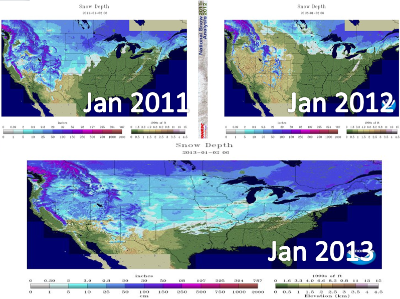
We do have a winter this year though as many SNE locations are near or even slightly above snowfall where they should be this time of year, though this differs greatly for isolated cities and towns. One thing is for sure, we are WAY ahead of 2011-12 season nationally and even can make strong arguments we are even above (well above for some) the snowy winter season of 2010-11 at this point with much more winter days ahead. ~Anthony
I am not sure the above average snow fall is true for southern new englend. Other than the last snow storm of 5"-6" we have only seen a dusting here and there in Massachusetts north of Boston.
ReplyDelete