Many folks are just finishing brushing off from yet another late Winter 2013 major snowstorm for Southern New England. The late surge of winter continues now as we have officially welcomed in "Spring" now. Upstream strong Greenland Blocking (-NAO) has really had a hold on us since early to mid February and shows no immediate signs of losing its grip on our area which means more below normal temperatures and a stormy/active storm track right into early April. There are now subtle signs that Spring may spring after the first week of April, but can say that that is not a given just yet. With our latest snowstorm , impressive numbers keep rolling in and records continue to fall. Worcester has been and continues to be the snowiest city in the Untied States this season (^ population of 100,000). Many locations now have set records for the Snowiest February and March combination ON RECORD and some dating back to the 1915-16 season. It really has been a very impressive Winter considering there were many folks ready to put this one in the bag ! The snow is just one aspect that will make this season now memorable, the other is the relentless battering and reshaping of our beloved Southern New England shorelines.
<<<GRAPHICAL MODELED SURFACE SEA LEVEL PRESSURE
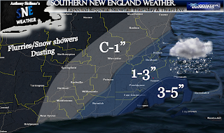
So, here we go again, our next system comes in Thursday afternoon and overnight. This is not a direct hit from a coastal storm rather another potential Inverted Trough or convergence zone setting up between a vigorous Upper Level Low Pressure system off to our northwest and another surface low well to our south and east. This will focus an area of snowfall to break out near the East Coast of Southern New England anytime after 11am though probably more likely towards 2-3pm and continue through the evening hours and possibly linger right into Friday morning especially for the outer Cape and Nantucket . All levels support snow, fluffier to the west and a bit wetter to the east. There lies a compromise where heaviest precipitation looks SE, with a bit less west though a drier snow. Dewpoints will be marginal on the outer Cape though temps aloft will be plenty cold enough. Not many if other impacts are expected with this storm other than the timing again may be rough with the evening commute, especially east of Interstate 95 , Route 3 in eastern Massachusetts and Route 6 along Cape Cod. So all in all a low impact event but yet another shot at a potential plowable March snowfall in the Winter now that seems to never end.
<<<EXPECTED SNOWFALL (REMEMBER TO USE AMOUNTS RANGE.. LOW #'S LIKELY, HIGH POSSIBLE)
This may not be the last of it, and If I were a betting man, it is not the last of it. The presence of a remarkably Strong Greenland Block much like December and January of 2010-11 and 1995-96 will continue and the 500mb pattern will continue to remain conducive for coastal development. There is also a potential bigger storm in the works for Monday and Tuesday which looks like a potential carbon copy to the one that just passed. Stay tune for more on that. Thank you for reading and hang in there Spring lovers, this is the price we pay for that amazingly gorgeous early Spring last year which featured many in the 70's and low 80's at this time. Certainly not the case this yr. ~ANTHONY


No comments:
Post a Comment