Sunday, November 25, 2012

Potential Miss Likely ?.. Still Early.


So far in November we have been below average temperature wise daily more than above for many locations throughout Southern New England, except for a brief period of warmth  from the 8th -13th . The issue is that we have also been very dry and well below normal precipitation as well.
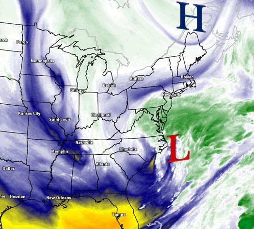
 The cold is explainable due to an active northern stream coinciding with a North Atlantic Oscillation which predominately remains in a negative phase. The precipitation side is a bit more complex. Rumors have been flying of a potential storm Tuesday and Wednesday, and granted models for a time did indicate a minor to moderate snowfall around and south of The Massachusetts Turnpike  for a time, in the end the very cold and dry air that has been over us seems to be winning this battle and will squash most if not all moisture to work with in advance of low pressure well to our south with this potential storm Tuesday into Wednesday. Even when you have what you think all the players are lined up for a potent coastal storm, not all things align the way they need to be. The weather works in strange ways, and seems as though the harder you try to figure it out, the more you are left scratching your head. There are always surprises though and more often than not a storm does “surprise” us more than it does when it is expected, or at least it seems that way to many I’m sure. 

So the latest with this potential storm has a more zonal flow with the northern jet dominant and not able to tap into little Gulf of Mexico moisture that will be available and the dominating cold high pressure that will move off to the Northeast of Southern New England between now and when moisture starts to gather to our south and west will eventually hold most that moisture close and tight to northern flank of the precipitation shield as a WEAK low center passes south and east of our area Tuesday.  There are some indications that at the last minute the trough will tilt just enough in response to blocking to swing the storm more to the north and perhaps intensify within close proximity to the Gulf of Maine in the open waters and throw back light precipitation near the coastlines or even a weak trough development connecting between that low and a weaker one off the north of the Great Lakes forming a band of ongoing light precipitation.  This is yet to be seen or known, but a possibility nevertheless giving blocking trying to firmly establish right in time. To wrap it all up, chances are most if not all miss out on any snowfall other than a coating to an inch especially to the south and possibly to the east. 
There is another potential for a similar setup next weekend that bears and will be watched as well along with the fact that signs continue to indicate a near normal or below normal December in the temperature department and an active storm pattern developing into at least early December with some swings likely which could only help in storm development.  Lets all remember guys, it is VERY early in the game. Even for Boston, during our snowiest past winter seasons the first snow sometimes does not occur until mid -December and sometimes even holds of until early January. I feel many have become spoiled and expectations high especially the past few seasons with early , abnormal snowfalls. This is NOT the norm so to speak. So just hang in there. Meteorological Winter starts in 6 days with the official start to the Winter Solstice still over 3 weeks away. Thanks for reading guys !    ~Anthony 

Friday, November 16, 2012

Quiet heading into the Holiday..Or Is it?


After a few weeks of active weather battering our coastlines and displacing many from their homes and daily routines, the weather has quieted down dramatically and will continue to be quiet through early next week. It’s a very important travel week with the Thanksgiving Holiday on Thursday, so I try to leave all possibilities open. For now though, High pressure remains situated and will continue to do so off to our WSW blocking any moisture from coming in and giving a seasonable to a bit below seasonable flow from the  WNW.  There will be clouds from time to time and a slight increase in them as each day goes on from Saturday through Wednesday. Also, temperatures will moderate a BIT each day. It appears as though the entire period will remain dry. Afternoon breezes are possible, especially to the S &E.

If you remember earlier this week, I had mentioned a potential storm around thanksgiving, well, models and more importantly our Jet stream is forecast to be much flatter and a huge High Pressure system to the northeast of Southern New England looks to be in control per latest guidance. That Cold High (Heavy air) should win the battle with building moisture off the SE Coast of The United States trying to gather, form and push north.  If that High Pressure system does establish itself as forecast off the the northeast , you can forget about any storm coming this far north to have any direct effects on our area , it simply wont win that battle. Though If that high settles in a bit more west of its current Forecast, a shift closer to the coast most definitely could occur. For many though this is welcome news as many will travel in order to make it to their Thanksgiving destinations and quiet weather will be a welcome sight and as off now that is what we are likely to see. Though it remains a pattern that looks like it could QUICKLY change and at any time support a closer pass to the coast with a building Greenland Block by around Tuesday.
 The North Atlantic Oscillation  (NAO) forecast is now sending out mixed signals between a Positive and Negative phase slated right around the holiday which often sends guidance into an erratic frenzy, and this is why I continue to be reluctant not to toss this storm in the Atlantic Ocean just yet. I also believe it is the right decision due to the importantcy of travel next week to keep all doors of possibility open.
 Please stay tuned for further information on this potential which would look to carry a cold rain and wind if it were to pass close enough. Possibly even some snowfall to the interior. As of now , the trend is just some clouds, steady onshore flow , minor splash over on the coast and erosion, large surf,  and clouds and fog even if the storm does not impact us head on. Hopefully it stays quiet and dry for Turkey Day, and then weather lovers can really start to prepare for what may be a wild ride in December. Thanks for reading and do have a great weekend !     ~Anthony

Saturday, November 10, 2012

Brief warm up...Return to the old.

The Nor’easter is behind us thankfully and we saw a very nice day Saturday only to get better on Sunday with some approaching 60° under plenty of sunshine. Just a gorgeous day for Football at Gillette as The Bills come into town against The Pats at 1pm. The ridge maxes over Southern New England Monday ahead of a cold front to our west. Temperatures in the upper 50’s for northwestern zones and into the 60’s further east. What a treat! You will also notice a bit of humidity especially south and east as dew points will rise into the upper 50’s to low 60’s. All this is very temporary though as the cold front waits back in the wings for Tuesday. It will become breezy Tuesday ahead of the front passage and temperatures ahead of it will max in the morning hours near 60°
.
 Showers will associate with/ the cold front as well as the risk of a gusty thundershower as K Indicies rise into the 30’s. Behind the front we all turn much cooler for the reminder of the week with daily highs back into the 40’s and low 50’s and cold night time lows near/bellow freezing for the interior . At the same time the blocking we have had the past 3 weeks tries to become better established  up near Greenland and coincides again with building moisture near and off the coast of the southeast Untied States . We will have to watch again for potential coastal  Atlantic development next weekend with again interest along the northeast coast. Remember Hurricane season does not end until November 30th . Another coastal  storm would surely be added salt in the wounds for many who do not need it for sure, but Ms. Mother Nature could care less, its up to us to remain vigilant and prepare for anything she decides to throw at us. Thanks for reading !    ~Anthony

Tuesday, November 6, 2012


Our pending Nor’easter is taking shape off the Outer Banks of North Carolina this evening.  You can see the cold digging down behind the storm which again is creating a huge dip and a trough for another storm to ride up the east Coast and with stil a decent block in place, once again it has nowhere to go, Its trapped. The block could start to release Thursday am and “pull” the Nor’easter away with it. Not much has changed in the forecast over the past few days other than my statement that “it will not snow”. It is now likely that many across Southern New England will see their 1st flakes of the season and some likely to see accumulating snow.
The storm will continue to move off to the NNE and pass near or over benchmark 40/70 Wednesday evening. Meanwhile high pressure will be parked off to the north of New England along the Canadian. US border. That as you know means trouble most the time

. There are a few wildcards with this one. Very marginal cold support from 850mb temperatures. With them being marginal, in order for widespread snowfall, precipitation would have to come down at a heavy rate to “tap” into the colder air aloft. Right there, this setup favors higher elevations. The precipitation portion of this storm will likely be unknown right up to the last minute honestly though the potential is there for snowfall almost right to the coast. This does not seem likely to me at this point. Though from Worcester MA points west up and down SNE, it is. Also there is the chance of some freezing rain which could occur after an initial burst of snow across inland areas.

 This is due to models indicating a spike in temperatures aloft while surface temps remain at or below freezing for some. Dewpoint and wet bulb temps will need to be monitored very closely just prior and during the storm. In spite of that, I think most all transition to rain except those above 800-1000 ft. When night falls Weds eve, some could go back to snow. It all sounds like a lot, though in reality there is not much moisture to work with in this storm. Western SNE looks to see about a ½” of Precipitation and those numbers could increase to near 2” on Cape Cod & The Islands. The BIG story with this storm will be the winds. They will start to increase from south to north during the morning and reaching sustained speeds of  20-40 MPH from NW-SE by the afternoon.  Wind gusts will begin to approach 30-35mph across the interior, perhaps some near 45mph. Gusts closer to the coastline are likely to exceed 50mph with some near or over 60mph !. For this potential, High Wind Warnings and Wind Advisories have been posted by The NWS.

 There also is potential for minor to moderate coastal flooding and possible beach erosion.  Best guess on timing is as follows : Precipitation likely to start from S-N during mid morning Weds, ending Thurs mid morning, perhaps earlier. The winds will be steadily increasing come Wednesday morning and  maxing late night and calming down  early Thursday afternoon, though still remaining breezy. So, This is you typical Nor’easter. Unfortunately it come just over a week removed from the worst storm many in the Northeast have even experienced. My thoughts and prayers remain with those who lost love ones, are displaced and with out power. Its going to be cold !  Good news is with block releasing a bit and a huge ridge building to our west, we will turn mild early next week. But, guess what?….The block will be back…..That’s it for now , thanks for reading !  ~Anthony 

November Nor'easter Set To Strike

Freezing cold weather this eve is setting the stage as our Nor'easter approaches Weds. It now appears that the 1st snow will fall for many in Southern New England. Where snow does not fall, a cold rain will fall. There also is the risk for some freezing rain after initial burst of snow for some.  We still expect strong to damaging wind gusts, large swells , some beach erosion and possible power outages.

Thursday, November 1, 2012

#SNEwx *NEW BLOG** ... Not again !


Sandy is gone now but what she left was an area in shambles. My Thoughts and prayer continue to be with those affected on the East Coast..

So, Sandy is gone but her roots remain. The NAO (North Atlantic Oscillation ) was tanked during Sandy, perhaps the lowest in many many years along with a strong Greenland block.  We now see signs the NAO is transitioning or going “up” a bit. It is during these times of transition that weather can become eventful. The potential exist from another phasing of the northern and southern streams sometime mid next week. There will be a large upper level low pressure system over central Canada and a potent energetic disturbance coming out of Kansas to the southeast U.S. states. There will likely be a redevelopment of Low pressure off the  East Coast near the Carolina’s. At the same time a HUGE dip in the jet stream will be occurring along with the persistent blocking pattern well off to our northeast.  The Precipitation will wait for the Jet to go negative and then make its way up or just off the East coast, perhaps head northwest  before once again (Sandy) get pulled back by the negative jet and pushed in towards the E coast by The Greenland Block.  Timing looks to be late Wednesday perhaps through Thursday as another wave may ride up the negative trough.. Like sandy, there is no escape, though this will be NO Sandy , we got that stright?....Good ! . Not even close.
Still a bit too early for the specs, but the players are in place. Graphic 1: Below is a 2 panel model image of the 500MB chart and the 6 hour precip chart , timeframe Wednesday Pm
(Click Image to enlarge) On the left is the 500mb pattern, you can see the negative tilt to the jet representing initial precip may head out to sea.., though addition moisture to ride up from the southeast states could not escape. On the right: there you have a storm with quite heavy precipitation now. Low pressure situated JUST SSW of Southern New England. The low most likely would form off The Viginia coast then travel to the North...the block or "push' back to the coast is not as dramatic as it was with the Sandy set up, though is there and will be a major player.

Graphic 2 : Shows the 850MB winds which are the winds aloft and the potential for Gusts if brought down to the Surface. This model is indicating at least 75mph winds aloft at 850. But how do we get it to the surface?... From heavy precip and or convection which we know the model is showing here as well. Based on that , the potential exists for damaging winds with this storm, and in fact will be LIKELY if it forms . And Now the big question ....Will it be cold enough for snow? At this point the answer is no. 1: the track takes it west of Benchmark and continues N rather than ENE which would "pull" in the colder air behind it. With track further west, this would allow a more WSW -S flow bringing in higher dewpoint readings well above 32° to most of SNE, though slight shifts in track would mean a different story this go around. Stay tuned for the latest and Thank you for reading   ~Anthony