Wednesday, January 23, 2013

Frigid Air Holds, Light-Moderate Snow Early Saturday.


Frigid Arctic air is currently firmly entrenched across much of  Southern New England, the likes of which have not been seen since mid January of 2009, and for some dating back to 2008 ! Dangerously cold weather expected overnight with temperatures in single digits to below zero for most the region, along with brisk winds at times making the feel like well below zero region wide. Bitterly cold and dry weather expected again for your Thursday with highs on average 10-22°. Friday is frigid again for most though  milder air will start  creep in along and south and east of the Interstate 95 corridor during the eve hours as some moisture gets infiltrated from the southwest side of a developing ocean storm well to our south and east.
CLICK ON IMAGES FOR FULL SIZE VIEWS
The potential storm we are watching originates from Alberta Canada (Alberta Clipper) screams southeast from the Great Lakes , taps some gulf of Mexico moisture before transferring its energy off the Virginia coast or a bit further to the north into a primary low pressure system and tracks east northeast and should make a pass WELL southeast of the 40/70 benchmark. That in itself insures this is not a major event along with the added fact of the Arctic Dome to our northwest is far too heavy and will suppress most the heaviest moisture once again out of our area. This leaves the best opportunity of light-perhaps a moderate snowfall even over extreme southeast southern New England very late Friday into early morning Saturday. Snow showers and periods of light snow are possible for the rest of the interior. Still bears a bit of watching to swing some more moisture in here, but in the end it seem like more hope than reality as the Jet stream remains fairly flat and very progressive along with limited to zero blocking. Still this wont require much moisture at all to add up as ratio's look very favorable again. Any addition and any less moisture is what needs to be watch throughout  Thursday and early Friday.

It also fits well with the pattern that has been in place all winter with NAO indices hovering right around the neutral phase and tough to get the “Big One”. Milder air starts to creep in Sunday and especially next week when we may return back to normal or maybe even slightly above normal for this time of year. There are indications that once again it is short lived and more cold to perhaps arctic air return in time for February .    ~Anthony
UPDATED 5 DAY FORECAST GRAPHIC FRIDAY-TUESDAY

Monday, January 21, 2013

Updated Storm details Blog (215pm Monday)


After many topping off near or in the mid 50’s just yesterday afternoon, we now have readings in the 20’s and low 30’s and falling with extremely cold temperatures aloft as well ensuring precipitation coming in with our expected storm will be all snow.
We are watching 2 low pressure systems take shape this hour.
CLICK ON IMAGES FOR FULL SIZE VIEWS
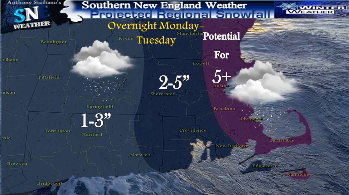
One is located off to the west of lake Ontario as almost like a clipper type system and one developing with increase pressure falls off the New Jersey coast. Its that low pressure that will intensify and pass southeast of the 40/70 bench mark early Tuesday. Though, a thin Inverted “Norlun” trough is expected to connect the two and bring potential for intense snowfall rates to east coast Massachusetts and southeast New Hampshire. 
Scattered snow flurries have already reported across western Ma, though accumulating snowfall will start to approach the south coast of Southern New England around 4-6pm, a quick burst expected for many even inland areas . After that burst , heavy snow will start to focus closer into the center of low pressure and snow, heavy at times 1-2  perhaps 3” an hour may develop along extreme east coastal Massachusetts, limiting visibility below 1/4mile overnight. 

That axis of heavy snow fall will then begin to pivot into northeast Massachusetts and southeast New Hampshire towards very early Tuesday am and most likely could have BIG morning rush hour implications once again. The forecasting aspect of storm has been pretty smooth with consistent signals from both our operational and ensemble guidance that may not reflect on the SNEweather snow map ,though  higher resolution models which tend to have better handle on these potential Mesoscale situations have been quite consistent with more precipitation into our area and that is how the snowfall expectation map was composed late Saturday with slight adjustment Sunday afternoon. Tricky forecast? It sure is ! But so aren't they all? There is an incredible amount dynamics to develop as low intensifies and nears the southeast SNE coast. Keeping in mind the whole time it could have been worse as still most intense moisture stays out to sea. But, when the arctic air meets the mild Atlantic Ocean and goes boom basically that’s our storm. The bands of intense snowfall much like that of a thunderstorm are likely to develop with possible thunder snow somewhere in the bands. Again, likely east coastal Mass up to perhaps Portland Maine.  Further shifts to the north and even to the south are possible even as the storm has commenced. For this reason, Hazardous Weather Outlooks are in place for interior SNE, Winter Weather Advisories closer to the coast and Winter Storm watches along the immediate shorelines.

We wont have to long to get up, brush off before we look ahead to our next potential near Friday which at its forecasting stage now looks to deliver Warning type snowfall (6+) potentially from Ohio to #SNE and carries potential for strong winds as well. A more detailed post on that tomorrow as well as hopefully a recap of the expected storm tonight and early Tuesday. That’s it for now, thanks for reading   ~Anthony

Saturday, January 19, 2013

"Norlun" or Nothing ?.... Latest Forecast Blog .

CLICK ON IMAGES FOR FULL SIZE VIEWS
We saw a fairly nice mid-January day out there Saturday in the 40’s for many, though gusty winds did not make it feel as mild, it certainly was more comfortable than Fridays highs in the 20’s ! One more mild day sets up Sunday with temps mildest for eastern zones as an Arctic front will be pushing in from the west/northwest late in the day which will bring quickly falling temperatures , gusty winds and perhaps, just perhaps a miracle flurry or snow shower during The Afc Championship at Gillette stadium in Foxboro tomorrow evening. Back to the gusty winds for Sunday, The Nation Weather Service in Boston has a *Wind Advisory* issued for The Berkshires of Western Massachusetts and Northwest Connecticut from 6am to 4pm Sunday with potential gusts up to 55mph.  Monday is shaping up to be a dry but cold day after the passage of the Arctic front  with high temperatures 20’s -30’s though crashing through the day. Clouds will increase late afternoon as a vigorous intensifying trough exits the Great Lakes, at the same time pressure will be falling off  and to the south of southern New England as a storm center starts to  take shape there . This will create an inverted trough and could be the focusing  axis for a “Norlun Trough” to develop during the nighttime hours. At least briefly until and if a surface low is able to form and intensify in time. The location of where this may form and how much snow is virtually impossible to predict, though I am favoring the Boston - Portland Maine corridor at this time with potential it sets up farther south and east.  The NAO going briefly Negative around then indicates the potential for rapid deepening just of our coastlines and potential to slow to a crawl.

 On this image GFS Model Ensembles indicate a good possibility of this along with the second graphic which shows three major models indicating the potential “Norlun” through surface pressure maps Of course This ALL depends on even IF it develops and its all about the timing as they are rather rare and usually not widespread though many indications at least snow showers will be around for many.

  Temperature both aloft and at the surface will be conducive to support all snow . With temps so cold, the normal 10:1 snow to liquid ratio would be more on the order of 15-20:1. This means it wont take much moisture at all to put down a few fluffy inches at least even for other areas. Its like putting some water in a damp sponge, it wont drip off until you squeeze it, and when you do quite a bit of moisture is wrung out. It continues to bear constant watching as it could form entirely too late and just leave us High , dry and frigid Tuesday and beyond. Speaking of beyond, signs are another storm system approaches late week with a few scenarios possible with that. It DOES have potential to drop more snow and perhaps moderate amounts region wide but is noted it also carries big bust potential due to arctic air in place acting as a suppressor forcing most if not ALL moisture to the south and east. More updates will follow on Sunday. Thanks for reading and GO PATS !  ~Anthony

Initial Storm Graphic Late Mon-Tues


Wednesday, January 16, 2013

*NEW BLOG* Quick Recap...Much more weather ahead .....


CLICK ON GRAPHICS FOR FULL VIEW
Just under 24 hours removed from many near 60° in Southern New England, a widespread 1-5” of snow fell on our area Wednesday am , not a huge deal for us hardy folks, but the timing was a nightmare for morning travelers. All got in on the action except for Cape Cod where once again the mild Atlantic ocean trumped any wildcards that may have existed . They may be next though, it’s a process this season to get that water cooler but cold weather ahead will help for sure. We are watching a third and final wave of Low Pressure riding along the boundary which has now pushed a bit farther to the east today. This low is likely to stay far enough off to the south and east to spare most of the area from seeing anything, though just enough moisture may get thrown up into the South Shore of Massachusetts and the Cape and the Islands especially to cover the ground in white. Lower chance of this extending back into Rhode Island and even a lover probability for any portions of Connecticut . What will have to be watched and is having a tough time being picked up by our computer guidance is a light NE wind which may bring snow showers to east coastal Ma. perhaps as far north as Cape Ann .

 This is for late Thursday and early Friday as that looks to scoot on by due to lack of blocking. Quick mover again. Other forecasting issues with this system is whether it tries to phase with new incoming northern jet or if  the incoming cold air just too heavy and will  surpress the storm ?. That usually is the case and will go with it. Even with exploding storm well to our south and east enough gradient will be in place to create precipitation. 
Beyond that , we got a fairly nice day setting up for Saturday and most Sunday, though winds will pick up late Sunday and especially Monday (timing still in question a bit) as temps will crash ahead of the Arctic front plowing in from Canada forced down via Polar Vortex with snow shower and squalls ahead. The heart of the coldest air of the season can now almost be confidently pinned down to arrive Monday through most of next week. High temperatures look to struggle to get out of the 20’s with nighttime lows in the single digits and teens at best ! 

 There are a couple disturbances next week that bear watching as clipper systems (Alberta) will comes across the Great lakes  and with potential NAO slightly negative, these things can explode once they even touch The Atlantic Ocean. Winter is back!   ~Anthony.  Check out the UPDATED extended forecast graphic for Fri-Tues
Click Here

Tuesday, January 15, 2013

*New Blog* This storm follows suit....


After January high temperatures 50-64° (30° above average for some) across southern New England on Monday, temperatures have since steadily fallen and leveled off Tuesday in the mid-upper 30’s and low 40’s which is only slightly above average for this time of year. Along a boundary of Arctic Air off to our west and northwest and mild air now just off to our southeast, a huge cloud and boundary has formed with a few waves of low pressure forming and riding up and along it. One wave went through yesterday evening with some light cold rain and sleet for some. A break in the action Tuesday day but now again we are watching moisture grow near Arkansas and Tennessee and will begin the track to the north along the same boundary and deliver a plowable snow for many folks starting after midnight through the daylight hours of Wednesday.
CLICK ON ALL GRAPHICS FOR LARGER IMAGES
 Initially temperatures aloft support snow for many, especially during times of moderate snow and banding. Those temperatures aloft will slowly rise heading through the early day hours on Wednesday. For this reason and the fact the south coast and southeast Massachusetts will see the rise 1st and quicker, mixing with  and changing to plain rain for some. Again this is a tough call right along the interstate 95 corridor, much like all the other systems so far this winter. I expect this storm to be no different as the waters in the Atlantic Ocean off the southern New England coast are still running above normal. This is not a big event but the timing off it will carry potential commute issues in the morning and possible school delays and or a cancellation or two. That storm warps up during the afternoon hours from southwest-northeast. 

A cold front comes through Thursday ushering in colder renewed air, though not arctic yet. Winds will be gusty Thursday though and there is the chance of a snow shower or two. We will have to watch yet another wave riding up the trough Thursday eve, though with the renewed blast of colder /drier air that one should miss to the southeast. It appears we warm back up a bit Saturday and the very first half of Sunday before huge changes are ushered in through Sunday afternoon and evening with the true Arctic Cold front prone to make passage. Could be a wild football game at Gillette. Kick off is 6:30pm. With mild temps for tailgating near 40° falling quickly on gusty north/northwest winds.

Beyond Sunday, forecast confidence surely decreases though signs have been pretty consistent with a very cold day Monday in the 20’s for many and a system/clipper moving towards and or just north of our area that may try to tap some Atlantic moisture before organizing off the coast. Will surely keep an eye on that. A brief bump in temps may occur after Tuesday with more Arctic Air incoming thereafter . Could be some wild swings ahead and in transition some storm systems to watch !    ~Anthony 

Wednesday, January 9, 2013

*NEW BLOG* Extremes? No. Shifts? Yes.


Many Winter and or snow lovers are starting to get antsy and asking themselves is this year another bust like last season ? While others just sit around with no complaints. Talk and signs before winter began were showing nice blocking and an active storm pattern. The signs failed us forecasters for the most part, though December did end on a colder than normal note and we did see a couple snow events in the northeast. Through all of this, its noted that Ski-Country in the mountains of central and northern New England, there have been NO complaints from those diehards, it has been a very fantastic beneficial season up there that has come to a bit of a halt in recent days only. Now that January is here temperatures have slowly started to moderate and will continue to do so as we head into the weekend and beyond. But, as the old saying goes “what goes up, must come down” eventually. You would think with some of the hype out there that we are headed for a deep Freeze, that just does not look like the case from what I am seeing. Sure cold air is cold regardless of how you cut it, but it is what is expected for Mid-January and especially in New England ! 
CLICK ON IMAGES FOR A LARGER VIEW
 I cant even be sure that once the flip is made which looks to be around the 16th, give or take that we will even dip below normal average highs which for this time of year are around 35° for a region wide southern New England average. It certainly is not an extreme switch we will be experiencing.
In the near term, a weak cold front is slipping though our region this evening with very little fanfare. It will be breezy to gusty at times Thursday as we will be on the boundary between cold and milder air to our southwest. Most Thursday will start off sunny for many with an increase in high clouds arriving during the late afternoon hours with building moisture off to our  west near The Ohio River Valley, which is our next shot at precipitation. Highs Thursday will again top off  in the low to mid 40’s. Thursday Night , with high pressure overhead, winds will turn light , so a good setup for radiational cooling and many if not all of the area returns to low 30’s upper 20’s and perhaps a few high elevation teens. Friday we may drop back a couple degrees as we await some possible showers late evening and overnight. No big deal there. Saturday we should be in a dry slot and we should see another rebound in temperatures into the mid-perhaps upper 40’s , which would be approximately 10° above average. Again, nothing dramatic. Late Saturday behind the warm up, a deep trough to our west will be digging east as MUCH colder air across the mid section of the country also tracks east. A Few more showers com in overnight Saturday. By the way, Sunday at Gillette for The Past Playoff game vs. The Texans looks mild and near 50°!

Its at this time things become  split a bit. Yes colder air heads towards the northeast U.S. , especially colder than what we have seen to start January, but nothing compared to certain January periods of past, and you do not have to go back far for evidence.  The sign of hope comes at 500Millibars. Recently dominated by building east ridge and a western trough, it will flip. It starts with The Polar Vortex descending south/southeast which in turn builds a  western ridge and eastern trough. It is during these times storms love to develop and breed and that can be seen on the 500mb pattern around the 17th coming out of the deep south near Texas. The big question remains does the cold air come in first and just deliver a period of seasonable to slightly below seasonal temperatures and dry weather beyond the 17th?, or does the timing of southern, southeastern moisture coincide with the arrival of colder air via Polar Vortex to form a storm system near the east coast ? Yet to be known, but the chance is there and for that as it bears watching for those who have been waiting patiently for it. 

Next question is does the colder air hang around by the time another system decides to swing up the coast or does it bring mild air in just ahead of it as has been case most the year and much like last season. We could get into a pattern that sends a few Alberta Clippers with light snow events also.  Teleconnections do favor the potential system near or around the 17th but again become split thereafter. It seems very hard to sustain either mild or cold air for any period of time this season so far. What needs to happen is the NAO needs to get to &  remain in a negative phase and blocking needs to set up and hold over or just south/southeast of Greenland. Until that happens  it is the same old same old pattern in place. Knowing it only takes one blockbuster storm to make a season memorable, there appears to be NO solid signs this is any type of special season. Although it still is very early, historically there have not been many, if any turnarounds of a magnitude that would make this season any different. I always feel if you have to dig deeper than normal to find what your looking for (cold air, snow) then its simply not meant to be. That lesson was learnt last season. I for one want nothing more to see this turnaround and bring cold and snow to stay for the rest of the winter, I just don’t see it  and will not dig deep to find or convince otherwise at this point. The beginning of the season was admittedly a personal forecast bust with constant talk of potential blocking which simply never occurred. I am not about to cover that mistake up by trying to “find” a correction. Lets just hope and watch the trends ahead and remember that February can bring the most intense winter storms to the northeast and March can roar in like a lion !     ~Anthony