Click on All Images for full size views
High Cirrus clouds can be seen this eve increasing to the south and southwest of Southern New England in advance of our next weather system. Monday was another spectacular day with many in 40’s and 50’s and more of that high March sun angle doing its thing melting a good deal of snow once again. Sun setting later helps with everyone’s past Winter Blue’s though lets not forget Winter does not end officially until March 20th. Upstream Greenland Block again re-establishes itself after the passage of this next system and brings at least 2 more opportunities of wintry precipitation before March’s end. Signals that one of these events could be significant.
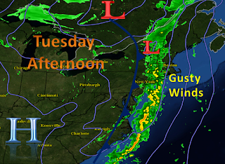
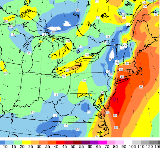
Next storm is a cold front stemming from an Upper level Low passage well off to our north and west. Moisture increases starting this eve with high cirrus clouds and begins to lower through the night ahead of a southerly flow ahead of front passage. We cant rule our some drizzle or a light shower overnight Monday into early Tuesday am during this moistening process, though the air is fairly dry so does not look like much of a big deal at all. More clouds lower into Tuesday am and more and more scattered showers will begin to form and move in from the south and southwest. It appears as though the heaviest moisture associated just along and or ahead of the actual front passage comes into western Southern New England zones after 10am Tuesday. This seems a bit ahead of “schedule” to previous thinking. Slowly showers and heavier downpours will increase and continue the track to the east towards and reaching the eastern areas by the evening commute. That timing does not look good for folks commuting near metro Boston and in fact for all commuting up and down the interstate 95 corridor . In addition to the heavy downpour potential will be a period of gusty winds increasing as early as Tuesday mid morning on the order of 30mph for many and increasing to near 40-45mph as the day goes on especially south and east of The Massachusetts Turnpike. Also to note that a rumble or two of thunder is not out the question.
Overall it looks like the consensus of guidance at this time is indicating ½”-1.00” of rainfall looks likely. Perhaps a few isolated higher amounts in heavier downpours possible. For this reason and in combination of still a deep snow pack (for some) despite recent melting has prompted the issuance of a *Flood Watch*. The watch is in effect from Tuesday afternoon through Wednesday morning and any flooding is expected to be minor and confined to small streams. Those in prone areas should watch for potential warnings which means flooding is either happening or imminent. Hopefully the latter.
After that storm passes it appears as though strong upstream Greenland Blocking (-NAO) will once again take shape and cooler weather ensues. There are also a couple systems of note to keep and eye on as the 500mb pattern again becomes conducive for coastal East Coast development. All will be monitored and further info will be issued as it becomes available ~Anthony


No comments:
Post a Comment