Click on images for a larger view
After a cold and snowy mid December, today in Southern New England found highs into the upper 40's and low 50's ! The "bump up" continues into Saturday as well as highs will be in the 50's for many to near 60°. The same holds true for most the region on Sunday as well. With Temperature fluctuations like this there surely will be some weather impacts expected as well. A frontal boundary is draped across the lower Great Lakes this eve and into central and northern New England and a couple waves of low pressure are expected to ride along that frontal boundary through Monday am bringing with it showers, downpours, possible thunder, strong wind gusts and warmth to the south of the boundary and potential ice , wintry mix and snow well north of the boundary.
The heaviest precipitation through Monday is expected to occur along and north of the front. If it were plain rain there would not be any issues but as temperatures skyrocket in the mid-upper levels of the atmosphere, surface temps will remain below freezing for many to the north of the front and that will bring a potential Ice storm to parts of northern New England Saturday night into Sunday especially but possibly not limited to central and eastern New Hampshire and much of Maine away from the immediate shores. South of the front surface temperatures will soar to about 20-25° above normal for this time of year with highs near or over 60° for much of SNE on Sunday. Dewpoints (measure of humidity) will be in the 50's too. It will feel almost muggy for the 1st *full* day of Winter on Sunday south of the front. The area to watch for potential *brief* icing would be extreme northern Middlesex County in eastern Ma as well as Essex County. I am not expecting any major concerns with the potential for ice but it does not take much . What is really insane is that temps near the MA/NH border will be in the 30's and near Taunton Ma and other areas in SNE it will be 30° milder! Such a short distance for such a gradient. These changes in the lower & upper levels as well as a screaming ridged Jet Stream into Canada will bring the potential for strong wind gusts into SNE late Saturday eve through Sunday on the order of 30-45 mph. As low pressure works off to the west and north of SNE late Sunday , cold west northwest winds will start snap back in here late Monday and especially Tuesday. Monday is the transition day though with still many SNE readings in the 50's . Its from that point on though that an arctic blast of air starts to get ushered into our area with highs remaining in the upper 20's to low 30's on Tuesday. A very cold Christmas Eve is shaping up into Christmas Morning with many teens likely away from the southeast shores. As low pressure works off the Northeast coast early Weds, winds will turn north over the relatively mild waters of the Atlantic and we could even see some Ocean Effect flurries or snow showers on Christmas Eve Day over Cape Cod. For SNE High pressure will be overhead and the forecast for Christmas looks like clear skies, calm winds and cold in the 20's and 30's . Below are some modeled images for Sunday Afternoon
Friday, December 20, 2013
Monday, December 16, 2013
Alberta Clipper Approaching. Details & Whats Ahead...
Click All Images For A Larger View....Two days removed from the first significant winter storm of the 2013-2014 season and now we are watching yet another system approach us this eve as northern branch energy dives east/southeast from central Canada currently north of Lake Superior. This energy/weak broad low pressure continues approaching southern New England this eve spreading a swath of light snow along the way. It's the ingredients for what we call an "Alberta Clipper". These clippers have a history of being moisture starved and usually drop minor advisory snowfalls and for many that is exactly what this one will do. But wait, we are still left in the same Jet Stream pattern just a few days ago and enough tilt to the Jet Stream that once that energy/vorticity nears the eastern shores of New Jersey it will spawn a secondary, coastal low off south of Long Island and start to intensify as it passes just east of the southern New England coastlines Tuesday evening. It is the formation of that new low pressure system in combination will remaining arctic air to the north being drained into the storm. This is the set up that brings us our accumulating snow for Tuesday.
If you are thinking that it seems like a while since we have seen one of these buggers, It has ! I don't have any specific dates but can tell you its been at least 2 yrs. Again, not a huge deal here but the timing could be rough for the evening commute as it is likely that moderate snow will be falling especially closer to Boston - Providence to the north /northeast into southeast New Hampshire. It is that area along with some favored higher elevations that could approach warning criteria snow of 6"/+ as this will be the area of greatest dynamics and lift being close to the center of a developing low pressure. In the image below the surface pressure trend /change shows falling pressure off the area of expected development during the mid to late morning hours.
At that time we will start to see more organized bands of snow closer to the coastlines. The storm is all snow for all the area except south and east of the Cape Cod Canal and the Islands as they will be close to the developing low which in turn allows milder air to come in off the Atlantic a bit of mix/rain *could make it as far north as Plymouth, Ma. Areas west of RT 24 in eastern Ma will see a dry fluffy snow. It is important to note with the cold temperatures as of late that the snow will start to adhere to all surface immediately. This storm is another quick mover with once again a lack of upstream blocking near Greenland (-NAO) , so may catch a few by surprise during the late afternoon, early evening hours as it progress off to the ENE. The concern is that the strongest part of the event commute during the Pm/evening commute. There are signals from guidance of steep mid level lapse rates (change in temperature of height) these values tend to lead to heavy convective-like precipitation and banding and yes even the potential for a rumble of thunder ! Something to monitor while now-casting early tomorrow and something to keep in mind if venturing out that you could get caught in a low visibility situation in heavy snowfall especially from Providence to Boston to southeast New Hampshire . The light snow starts to spread in here during the mid morning hours first in SW Connecticut and then will advance to the NNE thereafter reaching the eastern shores by 11am give/take.
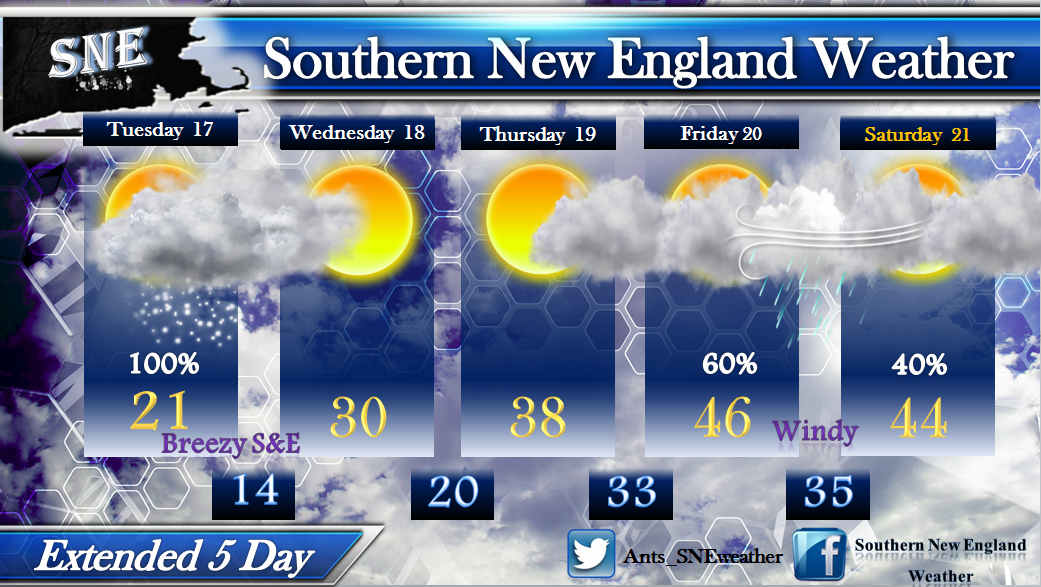
The other thing to watch for is some gusty winds to develop over Cape Cod & the Islands. Gusts 25-35 mph are possible into Wednesday morning. Its a cold day ! Highs only in the Teens for some , 20's for most and 30's over extreme southeast MA , the Cape & Islands. Wednesday we are left with some lingering morning clouds east before sunshine develops and we approach 30° for highs as a SNE average. The Warming trend will continue throughout the week with lots of clouds around after Thursday into the weekend , but mild ! Highs will be near/into the 50's possibly on Friday with windy conditions at times and showers developing late.
It appears as though the big trough driven by the Canadian Polar Vortex will work offshore towards Thursday allowing for an eastern ridge to build and bring the mild, showery conditions right into the weekend as well. Fear not though snowlovers...We need this to reshuffle things in the atmosphere and already there are indications the cold comes back in time for Santa and perhaps a storm system to watch as well. Thank you for taking the time to read the blog, I appreciate it. ~Anthony Oh..Winter begins Saturday ! Yup, has not even started yet.
If you are thinking that it seems like a while since we have seen one of these buggers, It has ! I don't have any specific dates but can tell you its been at least 2 yrs. Again, not a huge deal here but the timing could be rough for the evening commute as it is likely that moderate snow will be falling especially closer to Boston - Providence to the north /northeast into southeast New Hampshire. It is that area along with some favored higher elevations that could approach warning criteria snow of 6"/+ as this will be the area of greatest dynamics and lift being close to the center of a developing low pressure. In the image below the surface pressure trend /change shows falling pressure off the area of expected development during the mid to late morning hours.
At that time we will start to see more organized bands of snow closer to the coastlines. The storm is all snow for all the area except south and east of the Cape Cod Canal and the Islands as they will be close to the developing low which in turn allows milder air to come in off the Atlantic a bit of mix/rain *could make it as far north as Plymouth, Ma. Areas west of RT 24 in eastern Ma will see a dry fluffy snow. It is important to note with the cold temperatures as of late that the snow will start to adhere to all surface immediately. This storm is another quick mover with once again a lack of upstream blocking near Greenland (-NAO) , so may catch a few by surprise during the late afternoon, early evening hours as it progress off to the ENE. The concern is that the strongest part of the event commute during the Pm/evening commute. There are signals from guidance of steep mid level lapse rates (change in temperature of height) these values tend to lead to heavy convective-like precipitation and banding and yes even the potential for a rumble of thunder ! Something to monitor while now-casting early tomorrow and something to keep in mind if venturing out that you could get caught in a low visibility situation in heavy snowfall especially from Providence to Boston to southeast New Hampshire . The light snow starts to spread in here during the mid morning hours first in SW Connecticut and then will advance to the NNE thereafter reaching the eastern shores by 11am give/take.
The other thing to watch for is some gusty winds to develop over Cape Cod & the Islands. Gusts 25-35 mph are possible into Wednesday morning. Its a cold day ! Highs only in the Teens for some , 20's for most and 30's over extreme southeast MA , the Cape & Islands. Wednesday we are left with some lingering morning clouds east before sunshine develops and we approach 30° for highs as a SNE average. The Warming trend will continue throughout the week with lots of clouds around after Thursday into the weekend , but mild ! Highs will be near/into the 50's possibly on Friday with windy conditions at times and showers developing late.
It appears as though the big trough driven by the Canadian Polar Vortex will work offshore towards Thursday allowing for an eastern ridge to build and bring the mild, showery conditions right into the weekend as well. Fear not though snowlovers...We need this to reshuffle things in the atmosphere and already there are indications the cold comes back in time for Santa and perhaps a storm system to watch as well. Thank you for taking the time to read the blog, I appreciate it. ~Anthony Oh..Winter begins Saturday ! Yup, has not even started yet.
Thursday, December 12, 2013
Coastal Storm/Nor'easter On The Way
Its not quite "Winter" just yet but try telling that to Mother Nature. The active early to mid December pattern will roll on. It looked much different with the first few days of December in Southern New England averaging above normal temperatures but since we have been going nowhere but downhill and looks to be no prolonged end in sight to the cold. The change in the pattern started in its early stages towards late November and is continuing to date. It has been an impressive cold and snowy start to the season across much of the United States with relentless arctic air in the west and a nation that is now left with the highest percentage of snowcover to date going back to at least 2003.
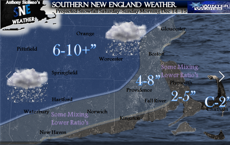
So, this gives us an idea of where we have been and where we stand now. Now we look to the future. More snow is heading into SNE this weekend and will be the biggest, most widespread snowstorm thus far this December.This storm will come with snow, heavy at times, some mixing near the shores and also some rain over far southeast SNE. The heaviest axis of most snow like many set ups like this occurs just to the north/northwest of the big cities as colder temperatures will bring in the "fluff factor" there even though less moisture may be in the cards for them as opposed to locations nearer to the coast. The coast will see a wetter type snow and possible mixing at times. A situation seen many times before and the snow map will echo that likelihood. In the below image of a snapshot of the current Water Vapor, you can see the ingredients coming together now for the storm ahead. First the northern energy now diving into the northwest US from Canada and building moisture over Texas which will soon tap the Gulf Of Mexico. These two meet up over SNE on Saturday , clash with large arctic high pressure to the north to bring us our winter storm/ Nor'easter. The included model image shows the idea of how it comes together as well.
Its still a tad too early to really get into specifics as far as timing and such but light snow looks to break out for most as early as 10am Saturday morning and will spread and intensify thereafter from SSW-NNE. The brunt of the storm comes Saturday evening into the first part of Sunday morning before tapering precipitation towards Sunday afternoon. Along with the Snow, mix and even rain for some mixing near the shores will come winds, especially but not confined to the eastern shorelines of SNE. Sustained ENE winds will develop between 20-30 mph for favored locations which the model image below gives a general idea. Wind *gusts* across much of SNE will be on the order of 30-40 mph for some and perhaps briefly approach 50mph for the Cape & Islands as the storm intensifies Sunday am off the coast heading into the Gulf Of Maine.
Waves 7-10' will develop just offshore of east and southeast facing shorelines and in combination with the expected winds may cause some splash over and minor coastal flooding at the times of high tide Sunday morning. So to wrap up , when all said and done the largest most impactful winter storm of the season is on the way and here is the expected snowfall map through early Sunday afternoon.
As far as where we are headed beyond this weekend I feel our active/COLD pattern will continue into at least next week. I am monitoring the potential for more snowfall early to mid next week along with possible record cold temperatures especially early in the week. Then Winter starts officially. Enjoy. ~Anthony
Quick Note: A few more finer details may arise and minor changes. Stay tuned to twitter and my SNE FB Fanpage for any further developments. Thank you for taking the time to read the blog.
Monday, November 25, 2013
Wrong time for Much Needed Moisture. Detailed Storm Blog
Well, we need rain in a bad way but unfortunately Mother Nature has decided to dispense it and a lot of it on arguably the busiest travel days of the year in the United States. Add to that the potential for strong to damaging wind gusts and we have a recipe for a potential traveling disaster.
The Arctic Front passage late Saturday and Sunday will be a distant memory by Wednesday morning as many in Southern New England will spike to or exceed 60° as a strong broad low pressure system to our south/southwest takes hold and intensifies with a very active south/southeast wind ahead of it right into our area. Enough cold air will be stubborn and in place at the onset late Tuesday that some wintry precipitation could fall across far western SNE before all levels of the atmosphere warm as the storm approaches closer to our area.
High clouds ahead of approaching coastal low are already on the increase and will continue to increase and lower through the daytime hours on Tuesday. We may actually see some wintry precipitation (light) break out in scattered form for central and especially western SNE early on Tuesday before we warm all levels. Just be aware of this and also be aware that it is very likely to not last long. The main batch of precipitation will start to enter south coastal Southern New England most likely after 5pm, advancing from southwest to north/northeast as the day progresses and reaching the eastern SNE shorelines by approximately 7-8pm . A few sleet pellets cant be ruled out briefly but will quickly transition to plain rain. A wind driven heavy rain event will commence over all of SNE Tuesday eve and last right into mid afternoon Wednesday. Though I am not a member of the “TSA”, I can certainly see some flight delays or even cancellations, so do be prepared and have some patience if you are traveling out of one of the East Coast hubs. Overnight Wednesday into the wee hours of Thursday morning as low pressure moves off to the north of our area cold air on the back side will snap back into SNE and could bring an end to the precipitation with a few flakes flying around. Very dynamic storm with northern energy, southern Gulf of Mexico moisture and rich Atlantic tropical moisture. This is not your typical “coastal storm”, though to many folks its effects will seem much like that of a Nor'easter, the fact is the winds will never go to the northeast until the low reaches the US/Canada border. Another aspect that prevents this system from being a Nor'easter is the lack of a present cold high pressure system to the north of SNE. Nor'easters thrive off Low pressure development moving into cold high pressures to the north and the tight pressure gradient created by it and a low pressure working into it, and that simply is not there this go around. In fact , this storm system will be working off pressure gradient as well but from a west to east perspective, not south to north. This also means the that system is rather progressive with nothing to hold it at bay. All the flow from all directions around the periphery of low pressure takes this thing quickly up the coast and off into southeast Canada before it “bombs out" into a very formidable storm .
Below is the expected rainfall through the entire event from Tuesday pm -late Wednesday. It appears as though with all guidance in agreement that most of SNE is in for a widespread 2-4” of rain. This would be the single most in a storm since June ! Again, much need at the worst time. Funny how Mother Nature sticks it to us at times. The precipitation shield will move from SSW-NNE and with that trajectory its relentless rains over the same areas. Training of heavy downpours are likely and we surely could see street flooding along with big puddles. It would be a good idea to clear storm drains of leaves and waste while you can early on Tuesday. Also try to get up on the roof and get those leaves out of those gutters! It will help, trust me. We will be on the eastern side of the storm so there will be a rich Atlantic moisture feed/transport along with some nasty churning winds at mid and high levels which will be transported to the surface in heavy downpours and thunderstorms….Yes, thunderstorms! Only 48 hours removed from arctic air. Welcome to November in Southern New England. So below is my thinking on rainfall expectations. There certainly could be isolated higher amounts but just too difficult at this time to pinpoint exactly where they line up.
Wind will be the other issue and on the increase again after seeing damaging winds Sunday as early as Tuesday eve with sustained winds of 20-30 mph creeping in from south to north. Sustained winds will increase to 20-40 mph east of Worcester , Ma up and down SNE. Widespread wind gusts will go to 40-50 mph with max gust of 60-65 mph over southeast MA early to mid day Wednesday. Winds of this magnitude are certainly capable for damage to power line and tree’s and loose property objects.
Coastal flooding not a huge deal as this is not a Nor’easter but there could be minor splash over near the shores. Waves *will* be impressive though, especially southeast facing shores. Possibly as high as 10-15’ with some offshore SNE swell reaching 18’ ! The storm is out of here by Thanksgiving though leaving cold in its wake with high temperature back into in the upper 20’s and 30’s for highs with a gusty NW wind.
The Arctic Front passage late Saturday and Sunday will be a distant memory by Wednesday morning as many in Southern New England will spike to or exceed 60° as a strong broad low pressure system to our south/southwest takes hold and intensifies with a very active south/southeast wind ahead of it right into our area. Enough cold air will be stubborn and in place at the onset late Tuesday that some wintry precipitation could fall across far western SNE before all levels of the atmosphere warm as the storm approaches closer to our area.
High clouds ahead of approaching coastal low are already on the increase and will continue to increase and lower through the daytime hours on Tuesday. We may actually see some wintry precipitation (light) break out in scattered form for central and especially western SNE early on Tuesday before we warm all levels. Just be aware of this and also be aware that it is very likely to not last long. The main batch of precipitation will start to enter south coastal Southern New England most likely after 5pm, advancing from southwest to north/northeast as the day progresses and reaching the eastern SNE shorelines by approximately 7-8pm . A few sleet pellets cant be ruled out briefly but will quickly transition to plain rain. A wind driven heavy rain event will commence over all of SNE Tuesday eve and last right into mid afternoon Wednesday. Though I am not a member of the “TSA”, I can certainly see some flight delays or even cancellations, so do be prepared and have some patience if you are traveling out of one of the East Coast hubs. Overnight Wednesday into the wee hours of Thursday morning as low pressure moves off to the north of our area cold air on the back side will snap back into SNE and could bring an end to the precipitation with a few flakes flying around. Very dynamic storm with northern energy, southern Gulf of Mexico moisture and rich Atlantic tropical moisture. This is not your typical “coastal storm”, though to many folks its effects will seem much like that of a Nor'easter, the fact is the winds will never go to the northeast until the low reaches the US/Canada border. Another aspect that prevents this system from being a Nor'easter is the lack of a present cold high pressure system to the north of SNE. Nor'easters thrive off Low pressure development moving into cold high pressures to the north and the tight pressure gradient created by it and a low pressure working into it, and that simply is not there this go around. In fact , this storm system will be working off pressure gradient as well but from a west to east perspective, not south to north. This also means the that system is rather progressive with nothing to hold it at bay. All the flow from all directions around the periphery of low pressure takes this thing quickly up the coast and off into southeast Canada before it “bombs out" into a very formidable storm .
Below is the expected rainfall through the entire event from Tuesday pm -late Wednesday. It appears as though with all guidance in agreement that most of SNE is in for a widespread 2-4” of rain. This would be the single most in a storm since June ! Again, much need at the worst time. Funny how Mother Nature sticks it to us at times. The precipitation shield will move from SSW-NNE and with that trajectory its relentless rains over the same areas. Training of heavy downpours are likely and we surely could see street flooding along with big puddles. It would be a good idea to clear storm drains of leaves and waste while you can early on Tuesday. Also try to get up on the roof and get those leaves out of those gutters! It will help, trust me. We will be on the eastern side of the storm so there will be a rich Atlantic moisture feed/transport along with some nasty churning winds at mid and high levels which will be transported to the surface in heavy downpours and thunderstorms….Yes, thunderstorms! Only 48 hours removed from arctic air. Welcome to November in Southern New England. So below is my thinking on rainfall expectations. There certainly could be isolated higher amounts but just too difficult at this time to pinpoint exactly where they line up.
Wind will be the other issue and on the increase again after seeing damaging winds Sunday as early as Tuesday eve with sustained winds of 20-30 mph creeping in from south to north. Sustained winds will increase to 20-40 mph east of Worcester , Ma up and down SNE. Widespread wind gusts will go to 40-50 mph with max gust of 60-65 mph over southeast MA early to mid day Wednesday. Winds of this magnitude are certainly capable for damage to power line and tree’s and loose property objects.
Coastal flooding not a huge deal as this is not a Nor’easter but there could be minor splash over near the shores. Waves *will* be impressive though, especially southeast facing shores. Possibly as high as 10-15’ with some offshore SNE swell reaching 18’ ! The storm is out of here by Thanksgiving though leaving cold in its wake with high temperature back into in the upper 20’s and 30’s for highs with a gusty NW wind.
Sunday, November 17, 2013
The Pattern Ahead And Some Winter Thoughts
Overall it has been a very quiet Autumn thus far in Southern New England, temperatures have been up and down just like we are accustomed to this time of year. Many locations saw their first flakes and also their first minor snowfall accumulation and it came right around the average date that it should do so. We have seen some strong cold front passages this season , but they have come with little fanfare in the precipitation department. So, as we now are just past mid month November, where do we stand compared to the mean average of years past in both temps and precip?..The graph below shows the numbers of each. (Click all images to enlarge and please do not redistribute)
So now the big question, how does it look moving forward as we head towards late Autumn and approach the beginning of Winter? I am seeing signals of a pattern change starting as early as mid to late week upcoming. The pattern as of late has been a northern branch dominant one, again not uncommon for this time of year. As we approach December those northern storm tracks tend to shift further south leading to increasing opportunities for the northern energenic branch to phase with the moist southern branch of the jetstream leading to the increase in storm development over the south and south central United States. Step one is to first get a pattern that becomes conducive for storm development in locations that typically are the breeding grounds for storms to then approach the East Coast then either make the ride all the way up to the US /Canada border or depart the coastlines father south at some point. Its that time of year where we need to start watching for these potentials.
In recent years those that are "snowlovers" have almost come to expect a snowstorm in November and even October. Not the case this year, at least so far. Changes start next week and energenic disturbances to the north will start to descend further to the southern United States allowing for a more amplified pattern to take shape. There currently are no strong signals that this leads to any type of storm just yet but surely is an indication of a pattern becoming more conducive for development. That is apparent in the graphic below which shows the 500mb Ensemble Mean
and "spaghetti plots" as we approach mid to late next week. Showing amplified trough and northern (blue) and southern(red) streams getting closer to interaction.
Again, none of this indicates a set in stone storm or that one will develop, but they can and should start to as early as the upcoming weekend. One other graphic to show you is the favorable teleconnections starting to point in that direction as well. 1st is the North Atlantic Oscillation (NAO)..Which represents Upstream Greenland Blocking in a negative phase. Also conducive for storm development hovering around Neutral. Next is the Pacific/North American Pattern (PNA) which in a positive or trending positive phase develops a ridge across the western US which tends to lead to a trough over the east. Lastly is the Arctic Oscillation (AO) which is just as the name suggests , provides arctic air and a negative or trending negative phase usually does the trick. So, nothing set in stone yet, but its the conduciveness that has me keeping an eye on model as we approach December.
All signals I have gone over and all that I continue to see as the days pass continue to point to a "traditional" winter over the Northeast. This means the snowiest periods should occur in December, especially mid to late month into 1st half of January . Appears a very cold February is in the cards along with a major storm threat early to mid month. Normal snowfall and temperatures should be the rule through March into April. As of now I feel near normal to slightly above normal snowfall is in the cards for the Northeast this winter season. Thank you for reading ! ~Anthony
Sunday, November 10, 2013
Its been a long time since I have composed a blog and apologize for that. It is very tough during my work season to do such though will most definitely have more time moving forward and once again look forward to that, so lets get into it...
I provided much talk about the *potential* of an East Coast storm in the works for the middle to latter half of next week. Its nothing more than I offer at any other potential that arrises. I had offered up two different scenarios at which potentially things could iron out and would issue a forecast the moment I felt one had validity over the other. That day came yesterday.
All signals in recent days have been pointing to the arrival of an anomalously strong 1040mb Arctic High diving south and east from central Canada. This will push a storm off to the north of SNE with a strong trailing cold front approaching Monday. That 1040 high will be positioned off to our west and building during that time. A High Pressure system of that magnitude and strength will now be enough to squash or suppress the southern jet to allow for any moisture that would try to ride up the East Coast and phase with the northern energetic jet to phase well offshore of Southern New England to bring minimal to zero effect from that. That is not to say that this upper level pattern and setup will leave us uneventful. As we approach Monday night into Tuesday as that huge High builds behind the cold front, the air will be so cold that a line of snow showers and squalls will break out *behind* the cold front along with gusty winds on the order of 25-35 mph. Travel for some across the Northeast will become a bit rough late Monday as squalls will reduce visibility at times. The potential is there for dustings to coatings and even a couple inches for areas hit the hardest. These squalls are often like thunderstorms and very hard to predict timing, location and intensity so watching radar and nowcasting becomes a necessity into Monday eve. Below is a graphic showing the setup and my thoughts as to the areas that may be impacted the greatest.
One aspect of the forecast that has remained is the surge of cold air that will come down on the eastern side of High Pressure. Temperatures will continue to fall progressively until they bottom out Wednesday am. Many locations east of The Rockies will see their temperatures fall to 10-25° below their average for this time of year and the coldest 2nd week of November since 2003 for some in Southern New England. Get some fresh wood cut ready to throw in that fireplace and get ready for spiked heating bills. The good news is the pattern is fairly quick to swing right back towards moderating warmth as a trough begins to build out west with a ridge developing into the eastern US.
In other news many in New England saw their first accumulating snows of the season this week, surely nothing to write home about for some but for others that 1st snow is just the time to write home......Always exciting ! My thoughts and prayers continue to be with the Philippines as they were devastated by Super Typhoon Haiyan, one of the worst cyclones to ever make landfall anywhere across the globe in history. ~Anthony
Subscribe to:
Posts (Atom)