Friday, February 15, 2013

More Snow, Wind & Cold on the way... #Winter


Upper level energy and cold pool aloft over the northeastern Great Lakes will create deepening trough and low pressure to form off  The Mid-Atlantic Saturday afternoon. The Low Pressure Center is then forecast to intensify rapidly as its heads of to the northeast and is likely to make a pass east of the 40/70 Benchmark early on Sunday and head into The Gulf Of Maine as another likely sub 970mb low in a recent string of them.
  Many locations today in the 40’s to near 50° today and some may find it hard to see this occurring. Truth is the temperatures are the least of the forecasting concerns as VERY cold air aloft is accompanied by energy and dynamics aloft from the west-northwest and this will result in a dynamic cooling process bringing snow as the predominant precipitation type for many except perhaps brief mixing south and east for a time ,though feel even there in time it will be mostly snow falling.  Snow showers and a period of Light snow looks to break out as early as the pre-dawn hours of Saturday. This could bring minor snowfall totals before and during the morning commute on the order of a coating to 2" to perhaps an isolated 3”. This precipitation shield moves from southwest to northeast and brings a lull in the action for at least a few hours before that primary low pressure development occurs well east of  The Delmarva Peninsula Saturday late afternoon . 
CLICK ON ALL IMAGES FOR LARGER VIEW
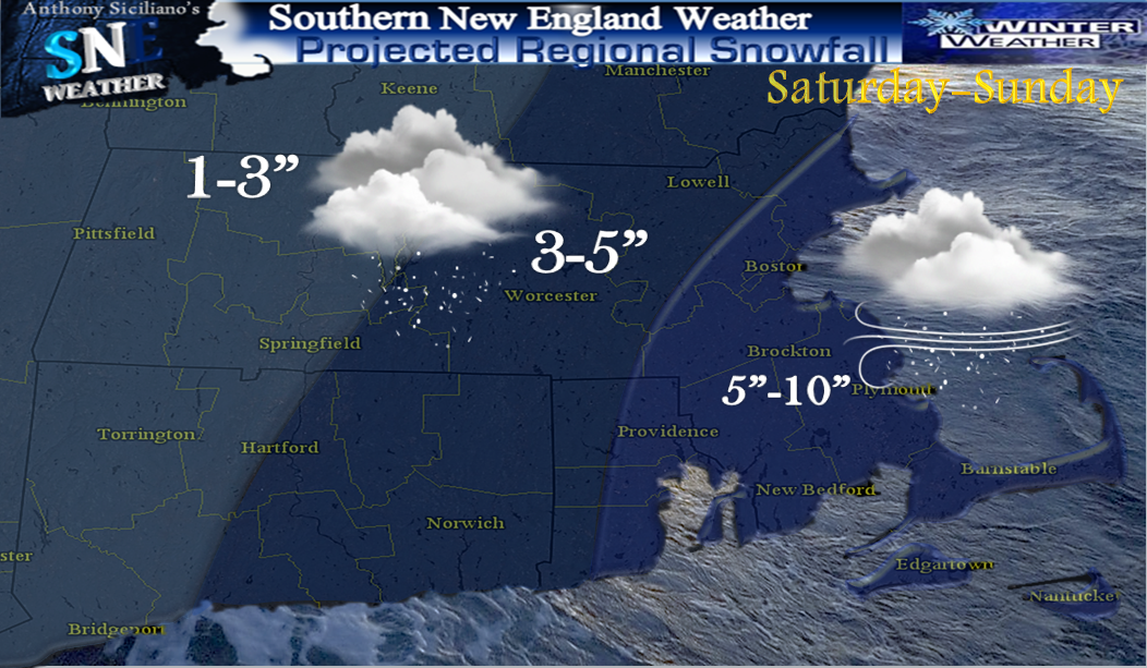
In advance of that low pressure snow again looks to break out for many with the heaviest axis focused across central and eastern areas of Southern New England throughout the night and into at least most of Sunday morning dropping more accumulating snowfall before low pressure takes off with its moisture into the eastern Gulf of Maine. (important to ALWAYS look at forecast RANGE amounts they are there for a reason.. low-high number, or likely-possible).  Along with the snow potential is the potential for an extended period of gusty winds developing on Saturday and possibly lasting through Monday with occasional gusts on the order of 30-45 perhaps  50mph at times from the west/northwest and could cause a few more isolated power outages. Not what many want to hear again and also with an expected cold blast.  The other aspect of this and it pertains to the winds that will shift to the west, northwest is how biting cold it will get through the day Sunday with falling into the 20’s for many and with those guts, wind chill values may dip near 0° or even well below for many. The wind and very cold air and low wind chills lasts right into at least early Tuesday.

Beyond this system, maybe some overrunning precipitation on Tuesday and perhaps icing for some. Beyond that, blocking will remain with a predominant negative North Atlantic Oscillation and a 500mb pattern that favors an amplified eastern US trough. That combined with multiple surges of moisture coming out of the Gulf Of Mexico, it appears a very active mid to late winter pattern is likely to shape up.    ~Anthony

Thursday, February 14, 2013

Graphical Storm Potential This Weekend ..Blog This evening.

Graphic represents the greatest probability of accumulating snow at this point though there are finer details in timing and especially amounts which hopefully become more clear through the evening and night and into Friday..As time and confidence warrants amounts will be plugged in.. a blog post is scheduled for this evening..Stay Tuned

Thursday, January 31, 2013

Wild Winds, January Is a Wrap. Back to Winter !


CLICK ON IMAGES FOR A LARGER FULL SIZE VIEW
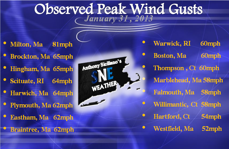
We just wrapped up a wild night Wednesday and a wilder early Thursday morning with widespread winds gusting 50-60mph with many locations reporting gust near 70mph or more ! In fact Blue Hills Observatory (elevation 635 ft) reported an unofficial gust to 81mph and was greater than that at any time during Super Storm Sandy back in October and was the worse winds the " Great" hill had experienced since 2006 as a whole. Very Impressive for sure ! All the ingredients had come together as forecast at the perfect time to create the damaging winds with an intense screaming Low Level Jet Stream just above our heads of more than 100mph. Thin convective lines of precipitation swept through the area aiding in bringing some of those gusts in modified form to the surface. Hence all the wildness and constant roars and howling that I’m sure kept many in Southern New England up for a good portion of the night and early morning hours. Accompanied by the winds were some heavy downpours and even some thunder reports in southwest Connecticut and parts of eastern Massachusetts. Many folks saw between a half inch to as much as just over an inch of rain. It was much needed at right at the last second, though many locations if not all will end January well below the norm for the month. Temperature soared ahead of  the winds and rains into the 50’s and 60’s for many. Worcester , Ma. set a NEW daily record high temperature on Wednesday of 56° smashing the old of 53° from 1938, and also set a NEW daily record high Thursday of 59° beating the old of 57° in 1988. Windsor locks in Connecticut also set a daily high Wednesday also of  61° topping the old of 59° set back in 1947 .This January sure was bizarre. I'm not sure in the years I have been doing climate graphs that one has looked quite like this.

All that warmth is now a distant memory as the low pressure that brought the wind, rain and warmth is now over southeast Canada intensifying now to near 950mb !  On the back side, winds are now from the west and or northwest ushering in much colder weather from here on out. We have even seen light snow reported across western Massachusetts and flurries reported throughout other areas of Southern New England Thursday afternoon and evening as some massive Lake Effect Streamers approached and broke off into our region.  Winter is back after a short reprieve for sure.  A weak shortwave passes to our south Friday morning, though the cold blast of drier air keeps most moisture at bay except for a few clouds especially south and east. An Ocean Effect light snow shower may pop up over extreme Outer Cape Cod . Along with also a few higher elevation snow showers for western Massachusetts and the Northwest hills of Litchfield county Connecticut . Other wise Friday is much colder and breezy with highs only reaching in the upper 20’s and 30’s region wide. Saturday looks quiet and again colder again upper 20’s and 30’s expected.

Sunday we watch for a couple scenarios that may develop to bring a light to perhaps moderate worse case  scenario snowfall favoring locations closer to the coast once again. Scenario one: Energy and moisture from an Alberta clipper approaches Sunday afternoon as a new low center forms offshore and once again the potential for an inverted “Norlun” trough becomes established. The location of which would favor a corridor from southwest Connecticut to down east Maine, zoning in near east coastal to northeast Massachusetts and southeast New Hampshire. Or, scenario 2 : The clipper energy swings south and a primary low pressure forms well near or southeast of the 40/70 benchmark and all of central and eastern areas of SNE get brushed by an intensifying coastal storm before it moves off to the northeast into the waters of the eastern Gulf of Maine . Both scenarios at this point favor coastal locations though a trend further west cant be ruled out nor can a complete miss which would not shock me either. A couple more clipper systems swing through/south of us next week also and bear close watching. More updates will be released tomorrow as needed. Thanks for reading, hope you enjoyed a completely whacky January and are ready for what February has to offer. It has a history of being dramatic at times . Buckle up   ~Anthony

Tuesday, January 29, 2013

*New Blog* Wild Weather Swings Ahead, Rain & Snow !


We certainly have some changing weather over the next seven days or so and it starts with temperatures and in those often fluctuations precipitation is forecast along the way. I will try to sort it all out as best I can in this blog. 
We remain near a boundary this evening separating warmer air to our south and west and colder air to our north, that once again is breaking out light precipitation this eve. Temperatures at the surface are JUST cold enough in some locations to support a bit of Freezing fog, mist or rain.  Others will see just a few cold rain showers and fog. Be aware and cautious of that If you are steeping out this evening as surfaces may be slick.  Towards the morning that boundary (Warm front ) will have lifter north of our region and with a strong Upper level Low deepening well off to our northwest near Quebec Canada, with a strong sharp cold front on its tail . This will send in a strong south/southwest flow ahead of it and temperatures rising into the 40’s towards dawn and rising there beyond until we max near or even over 60° perhaps ! Winds will gradually but surely increase during the day Wednesday peaking late evening with sustained winds 20-35mph and potential gusts 40-50mph inland with some approaching 60mph near the  east, south and southeast shores. For this potential the Nation Weather Service in  Boston has issued a practical region-wide *High Wind Watch* in effect late Wednesday eve and into early Thursday morning. Showers and downpours with a possible rumble of thunder comes through the area Wednesday evening from west to east. 
CLICK ON ALL IMAGES FOR LARGER FULL SIZE VIEWS
The potential exists for a half inch of rain to over 1" region wide . Its this convection that will aid in bringing gusts about 5,000 feet near 90 mph down to the surface in modified form. Wind Gusts of this magnitude are certainly capably and likely for scattered tree and wire damage. It would be a great idea to spend a few minutes in the milder, dry air early Wednesday to secure any loose objects that may become fly projectiles and hazardous to others. The showers and downpours end from west to east near dawn Thursday. It will remain breezy especially early Thursday and mild , again early on Thursday before colder air comes in behind the cold front passage from the west and northwest. There is a slight shot of a snow shower Thursday for western Massachusetts . All of our region will see much colder air infiltrate Thursday night and especially during Friday where highs will remain in the 30’s for many. This may set the stage for some addition moisture to ride up the newly settled trough over the northeast and bring a period of snow showers or light snow to our area late Friday afternoon, especially south and over hillier terrains . This again looks moisture starved and not much if anything is expected with this system. Though something to monitor throughout the day Wednesday. Seasonable to even perhaps slightly above seasonable weather returns for Saturday with highs in 30’s to perhaps low 40’s for some. The next system to watch will be  clipper moisture with an Upper Level Low Pressure system coming across the northwestern Great Lakes and Ohio River Valley late Saturday and early Sunday morning. There are indications and have been that at the last minute a new Low forms somewhere near or off the coast of Southern New England early on Sunday creating a potential weak inverted trough once again. Or “Norlun”. This would potentially enhance precipitation along east coastal areas from again anywhere from Cape Cod to Portland Maine.

 It remains simply to early to make a call on amounts or if this even develops, though the potential IS there, I can tell you that. Of course we saw this just a short time ago and we all know the cold arctic air won that battle suppressing most if not all moisture out to sea. This air does not look quite as arctic as the last, so maybe the setup becomes a bit more favorable this time around to bring some accumulating snowfall in here Sunday afternoon and evening. Another potential clipper swings from Alberta and the upper Great lakes  late Monday into Tuesday with potential eyes on Southern New England  ~Anthony

Saturday, January 26, 2013

Back ON The Roller Coaster, Wintry Weather In Transition


Cold Arctic air remains over Southern New England  this weekend, the likes of which have not been seen around here for 4 years for some !  An Upper level Low forms over the northern Great Lakes later on Sunday and is expected to pass well to the north of our area Monday evening. The recent cold will be in place and very stubborn to move, though at the same time warmer air aloft will be oozing in from southwest-northeast. During this transition, precipitation is expected to break out later Monday afternoon in the form of wintry precipitation for most. 
<<<<LATE MONDAY (CLICK ON IMAGES FOR LARGER VIEWS)
We have seen this overrunning situation on a couple occasions already this winter and this looks very similar and holds to the pattern. Though I cant argue with some data I am seeing that with the timing coming together this could be mostly frozen precipitation and maybe even mostly snow !  Again there is not a great deal of moisture associated with this wave though some locations may squeak out a quarter of an inch to perhaps a few isolated higher amounts.  Once again, this looks very progressive and is long gone by Tuesday dawn. 
Many clouds will be around with perhaps some fog and mist throughout times on Tuesday with temperatures finally rebounding into or near 40° for many.  We catch a brief break as a warm front lifts north of Southern New England through Tuesday afternoon and especially early Wednesday when some locations may approach 50° before we watch a VERY strong cold front waiting back in the wings that will break out downpours and perhaps a rumble of thunder late Wednesday as strong southwest flow develops just ahead of the passage . Wednesday night there could be a fine line and switch to snow especially central and western locations. I see a low chance even of a possible flash freeze with this, which can be extremely dangerous especially for motorist caught out at the wrong place in the wrong time. Its something to keep an eye on along with a screaming low level jet and potential for damaging winds near the eastern shores. The Thursday and into Friday situation is something that most definitely bears a watchful eye, once the passage occurs, the front/boundary may slow to a crawl as they often do just off our coastlines. Any addition wave of moisture could move north/northeast along this front and bring  some snowfall, especially eastern and southeastern locations as some of our ensemble models have indicated. Back to colder air thereafter with a potential for a storm next weekend. Could we re-introduce a "Norlun" ??  More updates on Sunday. Thank You for reading and enjoy the rest of your weekend   ~Anthony 

Thursday, January 24, 2013

Still In The Ice Box, Fluffy Snow Fri Eve South


CLICK ON IMAGES FOR LARGER VIEW
This appears the last frigid arctic night in the recent stretch, Wind Chill Advisories are up for the potential of values dipping to near -18°F throughout most of our areas except closer to coastal locations. But, don’t worry its frigid there too !  We make a bit of progress Friday but many will be in upper teens and low-mid 20’s at best. The saving grace looks to be much less wind with high pressure over head. Systems merge well south and east of southern New England Late Friday though enough moisture and plenty of cold air in place to bring flurries, and a period of light snow for some especially along the South coast of Connecticut, Rhode Island and SE Massachusetts  and Cape Cod and the Islands once again.  Minuscule moisture though we will take advantage of every flake that falls being so cold and a favorable fluff factor.

Time frame looks like after 8pm Friday evening from west/southwest to north/northeast and looks to wrap up before dawn Saturday  for most, though a few snow showers may remain over extreme east/southeast Massachusetts through the morning hours before that storm takes off and explodes into a large gale center. 

Wednesday, January 23, 2013

Frigid Air Holds, Light-Moderate Snow Early Saturday.


Frigid Arctic air is currently firmly entrenched across much of  Southern New England, the likes of which have not been seen since mid January of 2009, and for some dating back to 2008 ! Dangerously cold weather expected overnight with temperatures in single digits to below zero for most the region, along with brisk winds at times making the feel like well below zero region wide. Bitterly cold and dry weather expected again for your Thursday with highs on average 10-22°. Friday is frigid again for most though  milder air will start  creep in along and south and east of the Interstate 95 corridor during the eve hours as some moisture gets infiltrated from the southwest side of a developing ocean storm well to our south and east.
CLICK ON IMAGES FOR FULL SIZE VIEWS
The potential storm we are watching originates from Alberta Canada (Alberta Clipper) screams southeast from the Great Lakes , taps some gulf of Mexico moisture before transferring its energy off the Virginia coast or a bit further to the north into a primary low pressure system and tracks east northeast and should make a pass WELL southeast of the 40/70 benchmark. That in itself insures this is not a major event along with the added fact of the Arctic Dome to our northwest is far too heavy and will suppress most the heaviest moisture once again out of our area. This leaves the best opportunity of light-perhaps a moderate snowfall even over extreme southeast southern New England very late Friday into early morning Saturday. Snow showers and periods of light snow are possible for the rest of the interior. Still bears a bit of watching to swing some more moisture in here, but in the end it seem like more hope than reality as the Jet stream remains fairly flat and very progressive along with limited to zero blocking. Still this wont require much moisture at all to add up as ratio's look very favorable again. Any addition and any less moisture is what needs to be watch throughout  Thursday and early Friday.

It also fits well with the pattern that has been in place all winter with NAO indices hovering right around the neutral phase and tough to get the “Big One”. Milder air starts to creep in Sunday and especially next week when we may return back to normal or maybe even slightly above normal for this time of year. There are indications that once again it is short lived and more cold to perhaps arctic air return in time for February .    ~Anthony
UPDATED 5 DAY FORECAST GRAPHIC FRIDAY-TUESDAY